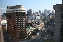
Sherbrooke Street
| French: rue Sherbrooke | |

Sherbrooke Street East at Berri Street
|
|
| Length | 31.3 km (19.4 mi) |
|---|---|
| Location | Between Avenue Westminster and Gouin Boulevard |
| Coordinates | 45°30′29″N 73°34′16″W / 45.50806°N 73.57111°W |
| Construction | |
| Construction start | 1817 |
Sherbrooke Street (officially in French: rue Sherbrooke) is a major east-west artery and at 31.3 kilometres (19.4 mi) in length, is the second longest street on the Island of Montreal. The street begins in the town of Montreal West and ends on the extreme tip of the island in Pointe-aux-Trembles, intersecting Gouin Boulevard and joining up with Notre-Dame Street. East of Cavendish Boulevard this road is part of Quebec Route 138.
The street is divided into two portions. Sherbrooke Street East is located east of Saint Laurent Boulevard and Sherbrooke Street West is located west. Sherbrooke Street West is home to many historic mansions that comprised its exclusive Golden Square Mile district, including the now-demolished Van Horne Mansion, the imposing Beaux-Arts style Montreal Masonic Memorial Temple as well as several historic properties incorporated into Maison Alcan, the world headquarters for Alcan.
Sherbrooke Street East runs along the edge (both administrative and topographic) of the Plateau Mont-Royal, at the top of a marked hillside known as Côte à Baron, and continues between the Jardin Botanique de Montréal and Parc Maisonneuve to the north and Parc Olympique to the south. The street is named for John Coape Sherbrooke, the Governor General of British North America from 1816-18.
...
Wikipedia
