Shellharbour, New South Wales
|
Shellharbour New South Wales |
|
|---|---|

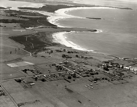
Aerial view of Shellharbour looking north c.1936
|
|
| Coordinates | 34°35′S 150°52′E / 34.583°S 150.867°ECoordinates: 34°35′S 150°52′E / 34.583°S 150.867°E |
| Population | 3,327 (2011 census) |
| Established | 1817 |
| Time zone | AEST (UTC+10) |
| • Summer (DST) | AEDT (UTC+11) |
| Location | |
| Region | Illawarra |
| County | Camden |
| Parish | Terragong |
Shellharbour (also known as Shellharbour Village) is a suburb located in the Illawarra region of New South Wales, Australia. It also gives its name to the local government area, City of Shellharbour.
The suburb is centred on the small recreational harbour named Shell Harbour. It has two main beaches, Shellharbour Beach, which runs to Barrack Point and Shellharbour South Beach, which runs toward Bass Point.
Shellharbour is undergoing extensive development with the construction of many new retail outlets and home-units. The main street is Addison Street, with many footpath cafés and shops and the Roo Theatre Company, running through the town and ending with the Ocean Beach Hotel opposite the harbour. Adjacent to the harbour is the Beverley Whitfield saltwater swimming pool and across from the Shellharbour Beach facilities is the Beverley Whitfield park, containing the Tom "Scout" Willoughby cricket oval.
Shellharbour hosts Habourside Markets on the fourth Sunday of the month, in Little Park.
The area was inhabited by indigenous Australians for thousands of years. European habitation began from about 1817 onwards. Shellharbour was originally known as Yerrowah and later as Peterborough.
Shellharbour's coastline is littered with 9 shipwrecks, and other historical sites like Bass Point which is home to various Aboriginal archaeological evidence. The shipwrecks date back to 1851, and are all protected under the Sate NSW Heritage Act 1977 & Commonwealth Historic Shipwrecks Act 1976.
Shipwrecks include:
...
Wikipedia

