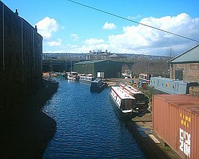
Sheffield Canal
| Sheffield Canal | |
|---|---|

Sheffield Canal boatyard
|
|
| Specifications | |
| Maximum boat length | 61 ft 6 in (18.75 m) |
| Maximum boat beam | 15 ft 6 in (4.72 m) |
| Locks | 11 (originally 12) |
| Status | Operational |
| Navigation authority | Canal and River Trust |
| History | |
| Original owner | Sheffield Canal Co |
| Date of act | 1793 |
| Date of first use | 1802 |
| Geography | |
| Start point | Sheffield |
| End point | Tinsley |
| Connects to | River Don Navigation |
| The Sheffield Canal | |||||||||||||||||||||||||||||||||||||||||||||||||||||||||||||||||||||||||||||||||||||||||||||||||||||||||||||||||||||||||||||||||||||||||||||||||||||||||||||||||||||
|---|---|---|---|---|---|---|---|---|---|---|---|---|---|---|---|---|---|---|---|---|---|---|---|---|---|---|---|---|---|---|---|---|---|---|---|---|---|---|---|---|---|---|---|---|---|---|---|---|---|---|---|---|---|---|---|---|---|---|---|---|---|---|---|---|---|---|---|---|---|---|---|---|---|---|---|---|---|---|---|---|---|---|---|---|---|---|---|---|---|---|---|---|---|---|---|---|---|---|---|---|---|---|---|---|---|---|---|---|---|---|---|---|---|---|---|---|---|---|---|---|---|---|---|---|---|---|---|---|---|---|---|---|---|---|---|---|---|---|---|---|---|---|---|---|---|---|---|---|---|---|---|---|---|---|---|---|---|---|---|---|---|---|---|---|---|
|
|||||||||||||||||||||||||||||||||||||||||||||||||||||||||||||||||||||||||||||||||||||||||||||||||||||||||||||||||||||||||||||||||||||||||||||||||||||||||||||||||||||
The Sheffield Canal is a canal in the City of Sheffield, England. It runs 3.9 miles (6.3 km) from Tinsley, where it leaves the River Don, to the Sheffield Canal Basin (now Victoria Quays) in the city centre, passing through 11 locks. The maximum craft length that can navigate this lock system is 61 feet 6 inches (18.75 m) with a beam of 15 feet 6 inches (4.72 m).
Sheffield is on the River Don, but the upper reaches of the river were not navigable. In medieval times, the goods from Sheffield had to be transported overland to the nearest inland port – Bawtry on the River Idle. Later, the lower reaches of the Don were made navigable, but boats could still not reach Sheffield. Proposals to link Sheffield to the navigable Don at Tinsley (and so to the Rivers Ouse and Trent, and to the Humber and the North Sea) were made as early as 1697, but these came to nothing.
In 1815, the Sheffield Canal Company was formed by Act of Parliament in order to construct a canal.
The surveyors' recommended route was to leave the River Don at Jordan's Lock, opposite where the "Holmes Cut" of the Don Navigation joins the river and follow the north side of the Don Valley to a basin "in or near Savile Street". When this was put forward the Duke of Norfolk's estate noted that it would preclude coal from their collieries at Tinsley Park and Manor reaching the canal and as the Duke was the largest financial backer of the project an alternative should be sought more favourable to their cause.
The alternative route was on the south side of the Don Valley, to terminate at a basin on the site of the former orchards of Sheffield Castle. This would require two series of locks, one, at Tinsley to raise the level from the river and a second, at Carbrook, to gain the necessary height for a level flow into the city centre. It was suggested that a short branch, known as "The Greenland Arm" should be built to afford access to Tinsley Park Collieries. Although the longer and more expensive option, the Duke's support meant that this route was the one for which parliamentary approval was sought.
The Act of Parliament was passed on 7 June 1815 with 182 subscribers, the Duke of Norfolk (2,000) and the Earl Fitzwilliam (1,000) being the largest contributors. The civil engineer William Chapman had prepared the plans, and he became the Engineer for the project, which would cost £76,000. The foundation stone of the canal basin was laid by Hugh Parker of Woodthorpe Hall on 16 June 1816 and all was ready for opening less than three years later.
...
Wikipedia
