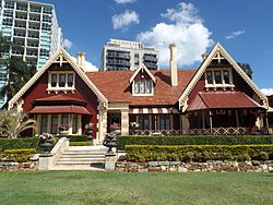
Shafston House
| Shafston House | |
|---|---|

Building in 2015
|
|
| Location | 23 Castlebar Street, Kangaroo Point, Queensland, Australia |
| Coordinates | 27°28′33″S 153°02′24″E / 27.4759°S 153.04°ECoordinates: 27°28′33″S 153°02′24″E / 27.4759°S 153.04°E |
| Design period | 1840s - 1860s (mid-19th century) |
| Built | 1851 - 1930s |
| Architect | Robin Dods |
| Official name: Shafston House, Anzac Hostel, Ravenscott, Shafston International College | |
| Type | state heritage (landscape, built) |
| Designated | 7 February 2005 |
| Reference no. | 600241 |
| Significant period | 1850s-1930s (fabric) 1850s-1960s (historical) |
| Significant components | ward - open air, attic, fence/wall - perimeter, driveway, residential accommodation - staff housing, lawn/s, gate - entrance, paving, residential accommodation - magistrate's house, service wing, trees/plantings, wall/s - retaining, terracing, cellar, depot - postal |
Shafston House is a heritage-listed villa at 23 Castlebar Street, Kangaroo Point, Queensland, Australia. It was designed by Robin Dods and built from 1851 to 1930s. It is also known as Anzac Hostel, Ravenscott, and Shafston International College. It was added to the Queensland Heritage Register on 7 February 2005.
Shafston House comprises a group of buildings constructed between 1851 and the 1930s, set in substantial grounds with frontage to the Brisbane River. The main house was constructed in several stages between 1851 and 1904.
The southern part of Kangaroo Point along the riverfront as far as Norman Creek was surveyed into acreage allotments by James Warner in mid-1850. The Rev. Robert Creyke (Church of England) purchased from the Crown two of these allotments (eastern suburban allotments 44 and 45) containing just over 10 acres with frontage to the Brisbane River, just within the Brisbane town boundary. A deed of grant was issued to him in November 1851. On portion 44 he constructed a single-storeyed house that he called Ravenscott. Creyke joined a number of Brisbane's early gentry and pastoralists from the hinterland who, in the 1840s and 1850s, established town estates along the Brisbane River, most of them just outside the official town boundaries. These included Newstead House (1846) near Breakfast Creek, Toogoolawah (later Bulimba House), (1849–50) across the river from Newstead, Riversdale (now Mowbray Park, early 1850s), Milton House (c. 1852 or 1853) just beyond the western town boundary and Eskgrove (1853) downstream from Shafston and Riversdale.
An 1851, sketch of Ravenscott attributed to visiting artist Conrad Martins shows a long, single-storeyed, low-set residence with verandahs and hipped roof, overlooking the Brisbane River. The grounds were mostly cleared and included outbuildings, the whole enclosed by a post and rail fence.
...
Wikipedia


