Shadyside, Pittsburgh
| Shadyside | |
|---|---|
| Neighborhood of Pittsburgh | |

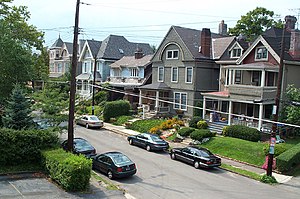
Street in Shadyside, 2001
|
|
 |
|
| Coordinates: 40°27′00″N 79°56′06″W / 40.450°N 79.935°W | |
| Country | United States |
| State | Pennsylvania |
| County | Allegheny County |
| City | Pittsburgh |
| Area | |
| • Total | 0.921 sq mi (2.39 km2) |
| Population (2010) | |
| • Total | 13,915 |
| • Density | 15,000/sq mi (5,800/km2) |
Shadyside is a neighborhood in the East End of Pittsburgh, Pennsylvania, United States. It has two zip codes (15213 and 15232) and representation on Pittsburgh City Council by the council member for District 8 (East Central Neighborhoods). Shadyside is drawn from the name of a 19th-century Pennsylvania Railroad station in the area, which was named for its shady lanes.
Another neighborhood institution is Shadyside Hospital, a member of the University of Pittsburgh Medical Center. Chatham University is located just across the southern edge of the neighborhood in Squirrel Hill, along with Pittsburgh Center for the Arts, which is also a part of Mellon Park. (A portion of Mellon Park is located in Shadyside as well as the Point Breeze neighborhood.)
In April 2014, Niche rated Shadyside the best neighborhood in Pittsburgh for millennials (Pittsburgh ranked 15th among cities nationally in the same study).
Shadyside is home to many upscale stores and boutiques, including Moda, Williams-Sonoma, and White House Black Market. In Shadyside, businesses (retail & restaurants) are located along three corridors: Walnut Street, Ellsworth Avenue, and S. Highland Avenue. Given the compact nature of this historic residential neighborhood, the three business corridors are all within walking distance of one another.
...
Wikipedia
