Sewanee, Tennessee
| Sewanee, Tennessee | |
|---|---|
| CDP | |

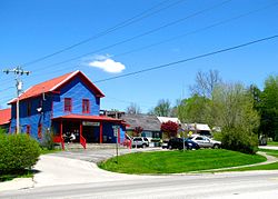
Businesses along US-41 in Sewanee
|
|
 Location of Sewanee, Tennessee |
|
| Coordinates: 35°12′4″N 85°55′17″W / 35.20111°N 85.92139°WCoordinates: 35°12′4″N 85°55′17″W / 35.20111°N 85.92139°W | |
| Country | United States |
| State | Tennessee |
| County | Franklin |
| Area | |
| • Total | 3.9 sq mi (10.1 km2) |
| • Land | 3.9 sq mi (10.1 km2) |
| • Water | 0.0 sq mi (0.0 km2) |
| Elevation | 1,929 ft (588 m) |
| Population (2010) | |
| • Total | 2,311 |
| • Density | 590/sq mi (230/km2) |
| Time zone | Central (CST) (UTC-6) |
| • Summer (DST) | CDT (UTC-5) |
| ZIP codes | 37375, 37383 |
| Area code(s) | 931 |
| FIPS code | 47-67140 |
| GNIS feature ID | 1301113 |
Sewanee is a census-designated place (CDP) in Franklin County, Tennessee, United States. The population was 2,311 at the 2010 census. It is part of the Tullahoma, Tennessee Micropolitan Statistical Area.
Sewanee is best known as the home of The University of the South, commonly known as "Sewanee."
Sewanee lies on the western edge of the Cumberland Plateau in the southeastern part of Middle Tennessee. It is located at 35°12′4″N 85°55′17″W / 35.20111°N 85.92139°W (35.201232, -85.921524). It is at elevation 1,929 feet (588 m).
The primary road in Sewanee is a merged section of U.S. Route 41A and Tennessee State Route 56, which connects the community with Monteagle to the east. In the western part of Sewanee, the two highways diverge, with US-41A descending the Plateau to the west and continuing toward Cowan and Winchester, and TN-56 descending the Plateau to the south and continuing toward Sherwood and Alabama.
...
Wikipedia
