Serra do Pardo National Park
| Serra do Pardo National Park | |
|---|---|
| Parque Nacional da Serra do Pardo | |
|
IUCN category II (national park)
|
|

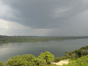
Pending rainstorm in the park beside the Xingu River
|
|
| Nearest city | Altamira, Pará |
| Coordinates | 5°28′48″S 52°59′20″W / 5.48°S 52.989°WCoordinates: 5°28′48″S 52°59′20″W / 5.48°S 52.989°W |
| Area | 445,408 hectares (1,100,630 acres) |
| Designation | National park |
| Created | 17 February 2005 |
| Administrator | Chico Mendes Institute for Biodiversity Conservation |
The Serra do Pardo National Park (Portuguese: Parque Nacional da Serra do Pardo) is a National park in the state of Pará, Brazil.
The Serra do Pardo National Park is divided between the municipalities of São Félix do Xingu (51.28%) and Altamira (48.72%) in the state of Pará. It covers an area of 445,408 hectares (1,100,630 acres). The park takes its name from the mountain range that stretches along the Pardo River. The mountains have an average height of 400 metres (1,300 ft) and rise to a maximum altitude of 546 metres (1,791 ft). The Pardo River defines the northwest boundary of the park.
On the north the park is bounded by the Rio Xingu Extractive Reserve. The west and south of the park adjoin the Triunfo do Xingu Environmental Protection Area. To the northwest it adjoins the Terra do Meio Ecological Station. To the east it is bounded by the Xingu River. The park is part of the Terra do Meio Mosaic, a grouping of protected areas.
The park was used for rubber extraction until the rubber crisis of the 1950s, then was occupied by squatters who extracted timber, and later was used for grazing cattle. The region was the scene of much deforestation and many land ownership conflicts. However, the park still maintains about 95% of its natural vegetation.
The Serra do Pardo National Park was created by decree on 17 February 2005. It is administered by the Chico Mendes Institute for Biodiversity Conservation. With the creation of the park the farms were expropriated and cattle removed in joint operations by ICMBio, the Brazilian Institute of Environment and Renewable Natural Resources and the federal police. The park is supported by the Amazon Region Protected Areas Program. The consultative council was created on 26 December 2012. The management plan was approved on 23 December 2015.
...
Wikipedia

