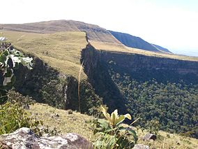
Serra Ricardo Franco State Park
| Serra Ricardo Franco State Park | |
|---|---|
| Parque Estadual Serra de Ricardo Franco | |
|
IUCN category II (national park)
|
|

Landscape in the park
|
|
| Nearest city | Vila Bela da Santíssima Trindade, Mato Grosso |
| Coordinates | 14°36′17″S 60°17′34″W / 14.6046°S 60.2928°WCoordinates: 14°36′17″S 60°17′34″W / 14.6046°S 60.2928°W |
| Area | 158,621 hectares (391,960 acres) |
| Designation | State park |
| Created | 4 November 1997 |
| Administrator | Fundação Estadual do Meio Ambiente de Mato Grosso |
The Serra Ricardo Franco State Park (Portuguese: Parque Estadual Serra de Ricardo Franco) is a state park in the state of Mato Grosso, Brazil. It protects the edge of a plateau on the border with Bolivia in the region of transition from cerrado to Amazon rainforest. The park has been poorly protected and is badly degraded in areas by deforestation and conversion to pasturage. It is threatened by illegal squatters, hunting and burning.
The Serra Ricardo Franco State Park is the municipality of Vila Bela da Santíssima Trindade, Mato Grosso. It has an area of 158,621 hectares (391,960 acres). It borders the Noel Kempff Mercado National Park in Bolivia, to the west. The Serra de Ricardo Franco is a plateau connected to the Serra de Santa Bárbara and Serra de São Vicente, which form the most visible relief feature of the Brazilian midwest. The park contains several left bank tributaries of the upper Guaporé River. The park holds the Jatobá waterfall, the highest in the state with a vertical drop of 248 metres (814 ft).
The Serra Ricardo Franco State Park was created by decree 1.796 of 4 November 1997, covering lands in the municipality of Vila Bela da Santíssima Trindade with an area of 158,620.85 hectares (391,960.7 acres). The objective was to protect water resources and the viability of movement of native fauna, preserve samples of existing ecosystems and allow controlled use by the public. There were already squatters in the park when it was created. An effort was made to reduce the size of the park in 2003 to exclude land used for productive activities. That year the state government allowed the deadline for expropriations to expire.
In November 2004 the State Environment Foundation (FEMA) presented a proposal approved by the state governor Blairo Maggi to reduce the size of the park by 100,000 hectares (250,000 acres). The reason was that the government no longer had money for expropriations. The areas would be those that had been occupied before the park was created, reaching to the foot of the mountains. In compensation, FEMA proposed to define an environmental protection area of 70,000 hectares (170,000 acres) in part of the area removed from the park. The mayor of the municipality said the proposal was very interesting. He was in favor of the park as long as it was not in the productive areas. He was not concerned about loss of ecological funding, which was small in comparison to the revenue from the new areas that could be planted with soybeans.
...
Wikipedia

