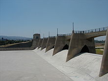
Sepulveda Dam
| Sepulveda Dam | |
|---|---|
 |
|
|
Location in the San Fernando Valley
|
|
| Country | United States |
| Location | San Fernando Valley, California |
| Coordinates | 34°10′02″N 118°28′24″W / 34.1671°N 118.4732°WCoordinates: 34°10′02″N 118°28′24″W / 34.1671°N 118.4732°W |
| Purpose | Flood control |
| Status | Operational |
| Construction began | 1940 |
| Opening date | 1941 |
| Construction cost | $6,650,561 |
| Owner(s) | U.S. Army Corps of Engineers |
| Dam and spillways | |
| Impounds | Los Angeles River |
| Height (thalweg) | 57 feet (17 m) |
| Length | 2.93 miles (4.72 km) |
| Elevation at crest | 725 feet (221 m) |
| Width (crest) | 30 feet (9.1 m) |
| Spillway type | Concrete ogee |
| Reservoir | |
| Total capacity | 17,300 acre·ft (21,300,000 m3) |
|
Website Corps Lakes Gateway - Sepulveda Dam |
|
The Sepulveda Dam is a project of the U.S. Army Corps of Engineers designed to withhold winter flood waters along the Los Angeles River. Completed in 1941, at a cost of $6,650,561, it is located south of center in the San Fernando Valley, approximately eight miles east of the river's source in the western end of the Valley, in Los Angeles, California.
Sepulveda Dam, along with Hansen Dam located in the north San Fernando Valley, was constructed in response to the historic 1938 floods which killed 144 people. Sepulveda Dam was placed at what was at the time, the current edge of the city. East of the dam the river was crowded into a narrow bottom by the city's growth. One legacy of Sepulveda Dam is its flood control basin, a large and undeveloped area in the center of the Valley, used mostly for wildlife refuge and recreation. But another legacy of the 1938 Los Angeles River flood was the post-World War II channelization of all the Valley's dry washes, which along with the post-World War II rapid suburbanization left the Valley with hot, dry, concrete-lined river bottoms instead of greenbelts. Although now, in part, these are being devolved as interconnecting bike paths.
Behind the dam, the Sepulveda Basin is home to several large recreation areas including Woodley Park, a model aircraft field, The Japanese Garden, a wildlife refuge, a water reclamation plant, and an armory. The Basin is kept free of urban over-building so that water can build up there during a prospective hundred-year flood.
It is an often-used location for car commercials.
When the 1914 flood caused $10 million in damages to the developing basin areas, a public outcry began for action to address the recurring flooding problems. During the following year, the Los Angeles County Flood Control District was formed. Some of the early flood control efforts included smaller areas of channelization and the planning for needed reservoirs. Taxpayers approved bond issues in 1917 and 1924 to build the first major dams. However, they were not willing to provide enough funding for the much needed and substantial infrastructure downstream of these dams. After two more destructive floods in the 1930s, most notably the 1938 flood, federal assistance was requested. The Army Corps of Engineers took a lead role in channelizing the river and constructing several dams which would create flood control basins behind them. Channelization began in 1938, and by 1960, the project was completed to form the present fifty-one mile engineered waterway. Included in this work were Hansen Dam, completed in 1940 and followed by Sepulveda Dam in 1941.
...
Wikipedia

