Sepik River
| Sepik | |
| River | |
|
Sediment plumes at the mouth of the Sepik (right) and Ramu (left) rivers
|
|
| Countries | Papua New Guinea, Indonesia |
|---|---|
| Regions | Sandaun, Papua, East Sepik |
| Tributaries | |
| - left | Yellow River |
| - right | April River, Karawari, Yuat, Keram |
| Source | |
| - location | Victor Emanuel Range, Papua New Guinea |
| - elevation | 2,170 m (7,119 ft) |
| - coordinates | 5°13′S 141°49′E / 5.217°S 141.817°E |
| Mouth | |
| - location | Bismarck Sea, Papua New Guinea |
| - elevation | 0 m (0 ft) |
| - coordinates | 3°50′30″S 144°32′30″E / 3.84167°S 144.54167°ECoordinates: 3°50′30″S 144°32′30″E / 3.84167°S 144.54167°E |
| Length | 1,126 km (700 mi) |
| Basin | 80,321 km2 (31,012 sq mi) |
| Discharge | |
| - average | 3,804 m3/s (134,337 cu ft/s) |
|
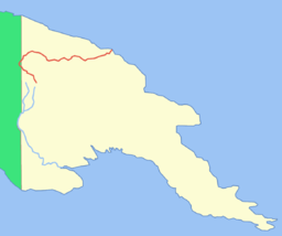
The location of the Sepik River
|
|
The Sepik River (/ˈseɪpɪk/) is the longest river on the island of New Guinea, and after the Fly and the Mamberamo the third largest by volume. The majority of the river flows through the Papua New Guinea (PNG) provinces of Sandaun and East Sepik, with a small section flowing through the Indonesian province of Papua.
The Sepik has a large catchment area, and landforms that include swamplands, tropical rainforests and mountains. Biologically, the river system is possibly the largest uncontaminated freshwater wetland system in the Asia-Pacific region.
The Sepik was named Kaiserin Augusta River by the German colonial explorer Otto Finsch, after the German Empress Augusta.
The river originates in the Victor Emanuel Range in the central highlands of Papua New Guinea. From its mountain headwaters near Telefomin, it travels north-west and leaves the mountains abruptly near Yapsei. From here it flows into Indonesian Papua, before turning back north-east for the majority of its journey following the Great Depression. Along its course it receives numerous tributaries from the Bewani and Torricelli Mountains to the north and the Central Range to the south.
...
Wikipedia


