Seogwipo
|
Seogwipo 서귀포시 |
||
|---|---|---|
| Administrative city | ||
| Korean transcription(s) | ||
| • Hangul | ||
| • Hanja | ||
| • Revised Romanization | Seogwipo-si | |
| • McCune-Reischauer | Sŏgwip'o-si | |

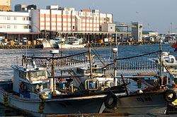
Seogwipo Harbor
|
||
|
||
 Location in South Korea |
||
| Country |
|
|
| Region | Jeju | |
| Administrative divisions | 12 dong, 3 eup, 2 myeon | |
| Area | ||
| • Total | 870.68 km2 (336.17 sq mi) | |
| Population (December 31, 2011) | ||
| • Total | 155,691 | |
| • Density | 178.82/km2 (463.1/sq mi) | |
| • Dialect | Jeju | |
| Website | www |
|
Seogwipo (Korean pronunciation: [sʌ.ɡɥi.pʰo]) is the second-largestcity on Jeju Island, settled on a rocky volcanic coastline in the southern part of Jeju Province, South Korea. In July 2006, Seogwipo's boundaries were expanded to include the entire southern half of Jeju island. A UNESCO World Heritage site and 2002 FIFA World Cup host, it had a population of 155,691 as of December 31, 2011.
Hundreds of Seogwipo’s oldest archeological artifacts were found in Saengsugwe Cave near Cheonjiyeon Waterfall on the south coast of Jeju. Afterafter an extensive excavation by a team of experts from Jeju National Museum in November 2010, hundred of Stone Age artifacts were unearthed. Another ancient location in Seogwipo is the village of Hamo. Artifacts found there during a 2005 excavation include pieces of earthenware and shell mounds from the Neolithic Age.
In the beginning, Seogwipo was a part of Tamna, an ancient kingdom of Jeju. The kingdom traded with other nations across the Korean peninsula and China during the period of the Three Kingdoms (1st century BCE to 7th century CE). The small port of Seogwipo was used to send tributes to Yuan, an ancient kingdom in China. Tamna briefly reclaimed its independence after the fall of Silla in 935. However, it was subjugated by the Goryeo Dynasty in 938, and officially annexed in 1105. In 1300, among the 14 villages that made up Tamna Prefecture were Hongro and Yerye, two regions of modern Seogwipo. Tamna maintained local autonomy until 1404, when Taejo of the Joseon Dynasty placed it under firm central control. During the Joseon era, three fortresses were built in the Seogwipo area. In 1416, southern Jeju Island was divided into the prefectures of Jeongui and Daejeong. The former included Hongro, and the latter, Yerye, which had been the urban centers of Seogwipo City.
In 1914, during the period of Japanese colonial rule, Jeongui prefecture and Daejeong prefecture were merged into Jeju-gun (gun meaning an administrative district bigger than a prefecture), and the two centers of Seogwipo became Jeongui-myeon and Daejeong. In 1915 the names were changed a second time, to U township and Jwa township. In 1935 the two townships were given the names they still have today: Seogwi and Jungmun. Seogwipo was greatly affected by Japanese colonial rule - it was used as a base that supplied marine products, and a whale processing plant was built near the port of Seogwipo. Twelve artificial caves made by the Japanese army still remain along the coast near Sammaebong Peak.
...
Wikipedia

