Sedgemoor
|
Sedgemoor Sedgemoor District |
||
|---|---|---|
| Non-metropolitan district | ||
|
||
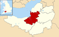
 Shown within Somerset |
||
| Sovereign state | United Kingdom | |
| Constituent country | England | |
| Region | South West England | |
| Ceremonial county | Somerset | |
| Admin HQ | Bridgwater | |
| Created | 1 April 1974 | |
| Government | ||
| • Type | Non-metropolitan district | |
| • Leader | Duncan McGinty | |
| • Council | Conservative | |
| • MPs: | Ian Liddell-Grainger C, James Heappey C | |
| Area | ||
| • Total | 217.90 sq mi (564.36 km2) | |
| Population (mid-2015 est.) | ||
| • Total | 120,300 (Ranked 186th) | |
| Time zone | GMT (UTC0) | |
| • Summer (DST) | BST (UTC+1) | |
| Post Code | TA5-9 | |
| Area code(s) | 01278 | |
| Website | www |
|
Sedgemoor is a low-lying area of land in Somerset, England. It lies close to sea level south of the Polden Hills, historically largely marsh (or "moor" in its older sense). The eastern part is known as King's Sedgemoor, and the western part West Sedgemoor. Sedgemoor is part of the area now known as the Somerset Levels and Moors. Historically the area was known as the site of the Battle of Sedgemoor.
Sedgemoor has given its name to a local government district formed on 1 April 1974, under the Local Government Act 1972, by a merger of the municipal borough of Bridgwater, the Burnham-on-Sea urban district, Bridgwater Rural District and part of Axbridge Rural District. The district covers a larger area than the historical Sedgemoor, extending north of the Polden Hills across the Somerset Levels and Moors to the Mendip Hills.
Sedgemoor does not mean "sedge moor", but is instead "marsh of a man called Sicga" from the Old Norse personal name Sicga and Old English mor "moor". The name was recorded as Secgamere in 1165.
Light industry now predominates, but traditional trades including peat extraction, willow crafts and cider making may still be found, in addition to livestock farming. The River Parrett provides a source of eels (anguilla anguilla) and elvers from January through to May.
...
Wikipedia

