Sedco Hills, California
| Sedco Hills, California | |
|---|---|
| CDP | |
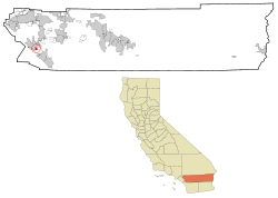
 Location in Riverside County and the state of California |
|
| Coordinates: 33°38′26″N 117°17′9″W / 33.64056°N 117.28583°WCoordinates: 33°38′26″N 117°17′9″W / 33.64056°N 117.28583°W | |
| Country | United States |
| State | California |
| County | Riverside |
| Area | |
| • Total | 1.6 sq mi (4.2 km2) |
| • Land | 1.6 sq mi (4.2 km2) |
| • Water | 0 sq mi (0 km2) |
| Elevation | 1,276 ft (389 m) |
| Population (2000) | |
| • Total | 3,078 |
| • Density | 1,923.8/sq mi (732.9/km2) |
| Time zone | PST (UTC-8) |
| • Summer (DST) | PDT (UTC-7) |
| ZIP code | 92330 |
| Area code(s) | 951 |
| FIPS code | 06-70784 |
| GNIS feature ID | 1652794 |
Sedco Hills is a former census-designated place (CDP) in Riverside County, California, United States. The population was 3,078 at the 2000 census. Sedco Hills was incorporated into Wildomar, CA in the July 1, 2008 Incorporation of Wildomar, CA.
Sedco Hills is located at 33°38′26″N 117°17′9″W / 33.64056°N 117.28583°W (33.640690, -117.285842).
According to the United States Census Bureau, the CDP has a total area of 1.6 square miles (4.1 km2), all of it land.
The name Sedco comes from the South Elsinore Development Company, a land company that developed the area in the past. The name Sedco Hills has become the informal name of that section of the Temescal Mountains east of Sedco Hills, west of Cottonwood Canyon Creek and south of the San Jacinto River.
As of the census of 2000, there were 3,078 people, 1,036 households, and 735 families residing in the CDP. The population density was 1,885.3 people per square mile (729.1/km²). There were 1,123 housing units at an average density of 687.8 per square mile (266.0/km²). The racial makeup of the CDP was 73.9% White, 3.3% African American, 2.0% Native American, 1.1% Asian, <0.1% Pacific Islander, 16.1% from other races, and 3.6% from two or more races. Hispanic or Latino of any race were 36.3% of the population.
...
Wikipedia
