Scusset Beach State Reservation
| Scusset Beach State Reservation | |
| Massachusetts State Park | |
|
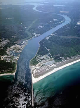
Cape Cod Canal with Scusset Beach at right
|
|
| Country | United States |
|---|---|
| State | Massachusetts |
| County | Barnstable |
| Town | Sandwich |
| Coordinates | 41°46′45.7″N 70°30′3.7″W / 41.779361°N 70.501028°WCoordinates: 41°46′45.7″N 70°30′3.7″W / 41.779361°N 70.501028°W |
| Highest point | Sagamore Hill |
| - elevation | 52 ft (16 m) |
| - coordinates | 41°46′51″N 70°31′00″W / 41.78083°N 70.51667°W |
| Area | 459 acres (186 ha) |
| Dedication | 1957 |
| Management | Massachusetts Department of Conservation and Recreation |
| Website: Scusset Beach State Reservation | |
Scusset Beach State Reservation is a state-operated, public recreation area located in the town of Sandwich in Barnstable County, Massachusetts, at the east end of the Cape Cod Canal on land formerly part of Sagamore Hill Military Reservation. In addition to its beach and campgrounds, prominent features of the park include Sagamore Hill, a one-time Native American meeting ground and site of World War II coastal fortifications, and a 3,000-foot (910 m) stone jetty that separates the canal and beach. Unlike most of Sandwich, this section of the town is on the mainland side of the Cape Cod Canal. The state park is managed by the Massachusetts Department of Conservation and Recreation under a lease agreement with the U.S. Army Corps of Engineers.
...
Wikipedia


