Scottdale, Georgia
| Scottdale, Georgia | |
|---|---|
| CDP | |

Steel LLC fabrication facility in Scottdale
|
|
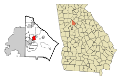
 Location in DeKalb County and the state of Georgia |
|
| Location in Metro Atlanta | |
| Coordinates: 33°47′40″N 84°15′44″W / 33.79444°N 84.26222°WCoordinates: 33°47′40″N 84°15′44″W / 33.79444°N 84.26222°W | |
| Country | United States |
| State | Georgia |
| County | DeKalb |
| Area | |
| • Total | 3.5 sq mi (9 km2) |
| • Land | 3.5 sq mi (9 km2) |
| • Water | 0 sq mi (0 km2) |
| Elevation | 1,030 ft (314 m) |
| Population (2010) | |
| • Total | 10,631 |
| • Density | 3,000/sq mi (1,200/km2) |
| Time zone | Eastern (EST) (UTC-5) |
| • Summer (DST) | EDT (UTC-4) |
| ZIP code | 30079 |
| Area code(s) | 404 |
| FIPS code | 13-69392 |
| GNIS feature ID | 0332993 |
Scottdale is a census-designated place (CDP) in DeKalb County, Georgia, United States. The population was 10,631 at the 2010 census.
Scottdale, aka SCD is located at 33°47′40″N 84°15′44″W / 33.79444°N 84.26222°W (33.794337, -84.262110). The unincorporated community is centered on East Ponce de Leon Avenue, between Decatur and Clarkston. The northern boundary is Stone Mountain Freeway; the eastern boundary is Interstate 285; the western boundary is roughly DeKalb Industrial Blvd.; and the southern boundary is roughly the city limits of Avondale Estates. The ZIP code for Scottdale is 30079.
According to the United States Census Bureau, the CDP has a total area of 3.5 square miles (9.1 km2), all of it land.
According to the 2010 census, there were 10,631 people residing in the CDP. The racial makeup of the CDP was 29.9% White, 37.7% African American, 0.20% Native American, 23.0% Asian, 0.01% Pacific Islander, 2.3% from other races, and 3.8% from two or more races. Hispanic or Latino of any race were 5.3% of the population. 12.7% of the population are Asian Indians. As of the census of 2000, there were 9,803 people, 4,010 households, and 2,201 families residing in the CDP. The population density was 2,818.2 people per square mile (1,087.6/km²). There were 4,236 housing units at an average density of 1,217.8/sq mi (470.0/km²). The racial makeup of Scottdale was 48.6% Black, 37.1% White, 0.19% Native American, 9.60% Asian, 0.18% Pacific Islander, 1.7% from other races, and 2.65% from two or more races. Hispanic or Latino of any race were 4.5% of the population.
...
Wikipedia

