Science Hill, Kentucky
| Science Hill, Kentucky | |
|---|---|
| City | |
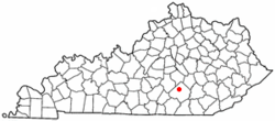
 Location of Science Hill, Kentucky |
|
| Coordinates: 37°10′31″N 84°38′8″W / 37.17528°N 84.63556°WCoordinates: 37°10′31″N 84°38′8″W / 37.17528°N 84.63556°W | |
| Country | United States |
| State | Kentucky |
| County | Pulaski |
| Incorporated | 1882 |
| Area | |
| • Total | 0.6 sq mi (1.6 km2) |
| • Land | 0.6 sq mi (1.6 km2) |
| • Water | 0.0 sq mi (0.0 km2) |
| Elevation | 1,132 ft (345 m) |
| Population (2000) | |
| • Total | 634 |
| • Density | 1,013.0/sq mi (391.1/km2) |
| Time zone | Eastern (EST) (UTC-5) |
| • Summer (DST) | EDT (UTC-4) |
| ZIP code | 42553 |
| Area code(s) | 606 |
| FIPS code | 21-68952 |
| GNIS feature ID | 0503071 |
Science Hill local /sɑːəns hɪl/ is a 6th-class city in Pulaski County, Kentucky, in the United States. The population was 634 at the year 2000 U.S. Census.
The community was named by geologist William J. Bobbitt, who visited to gather and analyze the local rocks, and applied to the local post office by William B. Gragg in 1874.
Science Hill is located at 37°10′31″N 84°38′8″W / 37.17528°N 84.63556°W (37.175284, -84.635654). According to the United States Census Bureau, the city has a total area of 0.6 square miles (1.6 km2), all land.
As of the census of 2000, there were 634 people, 249 households, and 184 families residing in the city. The population density was 1,013.0 inhabitants per square mile (388.6/km²). There were 275 housing units at an average density of 439.4 per square mile (168.5/km²). The racial makeup of the city was 99.21% White, 0.16% Native American, and 0.63% from two or more races. Hispanic or Latino of any race were 0.63% of the population.
...
Wikipedia
