Schwarza (Leitha)
| Schwarza | |
|---|---|

The Schwarza in the Höllental
|
|

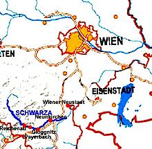
Map of the Schwarza in southern Lower Austria
|
|
| Location | Industrieviertel in Lower Austria |
| Basin features | |
| Main source |
Rohrer Sattel 902 m (AA) 47°52′N 15°48′E / 47.867°N 15.800°ECoordinates: 47°52′N 15°48′E / 47.867°N 15.800°E |
| River mouth | Discharges jointly with the River Pitten into the Leitha at Haderswörth 302 m (AA) 47°44′6.56″N 16°13′28.72″E / 47.7351556°N 16.2246444°E |
| River system | Danube |
| Landmarks |
|
| Physical characteristics | |
| Length | 78 km |
The Schwarza is a river in Lower Austria. It is a headstream of the River Leitha.
It rises on the saddle of Rohrer Sattel, flows through the Höllental gorge and the Schwarza valley. Near Haderswörth in the parish of Lanzenkirchen the Schwarza combines with the Pitten and is then called the Leitha. It is 78 kilometres (48 mi) long. The Schwarza is part of the Natura 2000 region known as "North Eastern Border Alps: Hohe Wand – Schneeberg – Rax" (Nordöstliche Randalpen: Hohe Wand - Schneeberg - Rax).
The Schwarza is characterized in its upper reaches by undercuts, high cliffs, gravel banks, pools and deep gullies. The lower reaches are strictly regulated as far as Schwarzau am Steinfeld. Only between Schwarzau am Steinfeld and Bad Erlach can the Schwarza spread out into wide meanders again. From Loipersbach the Schwarza runs along a sinkage section (Versickerungsstrecke), where the bulk of the water seeps into the gravel surface of the Steinfeld.
The river bed below the so-called "Dunkelstein Weir" in the municipality of Ternitz, usually only carries water at times of snowmelt and during heavy rain. The water flows through several works channels through the town of Neunkirchen. Here it powers some small hydro plants.
At the Peisching Weir most of the water from the River Schwarza (maximum 7,000 litres per second) is fed into the Kehrbach canal, which, in turn, feeds the Vienna Neustadt Canal.
...
Wikipedia
