Schuylkill Township, Chester County, Pennsylvania
| Schuylkill Township | |
| Township | |
|
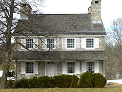
Headquarters of General von Steuben at Valley Forge
|
|
| Country | United States |
|---|---|
| State | Pennsylvania |
| County | Chester |
| Elevation | 138 ft (42.1 m) |
| Coordinates | 40°06′41″N 75°30′34″W / 40.11139°N 75.50944°WCoordinates: 40°06′41″N 75°30′34″W / 40.11139°N 75.50944°W |
| Area | 8.9 sq mi (23.1 km2) |
| - land | 8.6 sq mi (22 km2) |
| - water | 0.3 sq mi (1 km2), 3.37% |
| Population | 8,516 (2010) |
| Density | 956.9/sq mi (369.5/km2) |
| Timezone | EST (UTC-5) |
| - summer (DST) | EDT (UTC-4) |
| Area code | 610 |
|
Location in Chester County and the state of Pennsylvania.
|
|
|
Location of Pennsylvania in the United States
|
|
| Website: http://www.schuylkilltwp.com | |
Schuylkill Township is a township in Chester County, Pennsylvania, United States. It contains the village of Valley Forge. The population was 8,516 at the 2010 census.
Part of the Valley Forge Christian College's campus, formerly the location of the Valley Forge General Hospital, is located in Schuylkill Township. The other part is located in Charlestown Township. The campus straddles the township line.
The Moses Coates Jr. Farm, Gen. Frederick Von Steuben Headquarters, Moore Hall, Matthias Pennypacker Farm, and White Horse Farm are listed on the National Register of Historic Places.
According to the United States Census Bureau, the township has a total area of 8.9 square miles (23.0 km²), of which, 8.6 square miles (22.2 km²) of it is land and 0.3 square miles (0.8 km²) of it (3.60%) is water.
At the 2010 census, the township was 89.7% non-Hispanic White, 2.1% Black or African American, 0.1% Native American, 4.0% Asian, and 1.5% were two or more races. 2.6% of the population were of Hispanic or Latino ancestry [1].
As of the census of 2000, there were 6,960 people, 2,536 households, and 1,975 families residing in the township. The population density was 812.2 people per square mile (313.6/km²). There were 2,652 housing units at an average density of 309.5/sq mi (119.5/km²). The racial makeup of the township was 94.83% White, 1.67% African American, 0.07% Native American, 2.49% Asian, 0.03% Pacific Islander, 0.36% from other races, and 0.56% from two or more races. Hispanic or Latino of any race were 1.26% of the population.
...
Wikipedia


