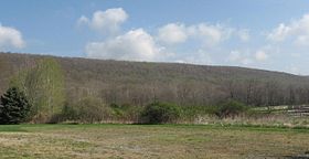
Schooley's Mountain
| Schooleys Mountain | |
|---|---|

Schooleys Mountain near Long Valley, NJ
|
|
| Highest point | |
| Elevation | 1,200 feet (366 m) |
| Coordinates | 40°49′45″N 74°47′37″W / 40.8292660°N 74.7934986°WCoordinates: 40°49′45″N 74°47′37″W / 40.8292660°N 74.7934986°W |
| Geography | |
| Location | Washington Township, Morris County, New Jersey, U.S. |
| Topo map | USGS Hackettstown |
| Climbing | |
| Easiest route | Road |
Schooley's or, officially, Schooleys Mountain is a mountain ridge in northern New Jersey that stretches from Lake Hopatcong in the north to Hampton in the south. It is centrally located within the southern Highlands, positioned almost equidistantly from the Kittatinny Valley in the west and the Piedmont plateau in the east. Schooley's Mountain is also one of the largest ridges in a group of geologically similar and parallel mountains, which include Allamuchy Mountain, Pohatcong Mountain, Scotts Mountain, and Jenny Jump Mountain.
Schooley's Mountain is separated from Musconetcong Mountain by a gap and the valley of Spruce Run, which bifurcates the mountain itself higher in its course. The mountain ridge extends about 20 miles northeast, being separated by Budd Lake and the South Branch Raritan River from Mooney Mountain. The northeasternmost point looks out upon Waterloo and the Musconetcong River, the valley of which lies upon its northwestern side; on the southeastern side is German Valley, drained by the South Branch Raritan River.
Prominent subsidiary peaks include Mount Kipp (951 feet (290 m)), at the southeastern tip, and Point Mountain (935 feet (285 m)), overlooking Anderson in the Musconetcong Valley. The summit of the ridge proper lies in an area of private homes on Kim Lane, on the northeastern part of the ridge.
The community of Schooley's Mountain is on top and in the middle of the ridge, which rises about 400 to 800 feet (120 to 240 m) above the surrounding valley.
...
Wikipedia
