Schlossberg Castle (Haidhof)
| Burgstall Schlossberg | |
|---|---|
| Burgstall auf der Flöss, Heidenstein |
|
| Gräfenberg-Haidhof-Schlossberg | |

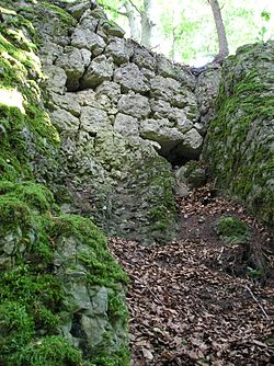
Image 1: The last wall remains of the castle in a rock crevice
|
|
| Coordinates | 49°41′34″N 11°13′09″E / 49.692808°N 11.219053°ECoordinates: 49°41′34″N 11°13′09″E / 49.692808°N 11.219053°E |
| Type | hill castle, spur castle |
| Code | DE-BY |
| Height | 560.1 m above sea level (NN) |
| Site information | |
| Condition | burgstall, a few wall remains and ditches |
| Site history | |
| Built | probably 2nd half of the 12th C |
| Materials | small ashlar construction |
| Garrison information | |
| Occupants | unknown |
The burgstall of Schlossberg Castle (German: Burgstall Schlossberg) also called the Burgstall on the Flöss (Burgstall auf der Flöss) or the Heidenstein, is a, now levelled, probably high mediaeval, nobleman's castle. It is situated above Haidhof, a village in the municipality of Gräfenberg in the Upper Franconian county of Forchheim in the south German state of Bavaria.
The burgstall of the old spur castle is freely accessible at all times and is used as a viewing point.
The burgstall is located in the Franconian Switzerland-Veldenstein Forest Nature Park at a height of 560.1 m above sea level (NN) on a rocky, southeast pointing hill spur known as the Flöss on the hill of Haidhofer Schloßberg (569 m above NN), which lies about three kilometres west-southwest of Egloffstein]] liegt.
Close by are Egloffstein Castle, the ruins of Thuisbrunn Castle in the eponymous village, a possible burgstall east of Thuisbrunn and the site of Burgstein Castle on the eponymous hill of Burgstein near the village of Ortspitz.
There are no records of the castle itself and its name is also unknown. The Nuremberg castle researcher, Hellmut Kunstmann, dates its construction to the second half of the 12th century and it had probably fallen into decay by the early 13th century. It lay on an ancient, medieval road that ran from Eggolsheim via Weilersbach, Kirchehrenbach, Leutenbach and Ortspitz, then past the castle and on to Haidhof, Thuisbrunn and Dörnhof and joined the road in the Trubach valley.
...
Wikipedia

