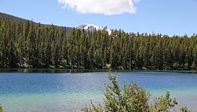
Scapegoat Wilderness
| Scapegoat Wilderness | |
|---|---|
|
IUCN category Ib (wilderness area)
|
|
 |
|
| Location | Lewis and Clark / Powell counties, Montana, United States |
| Nearest city | Missoula, MT |
| Coordinates | 47°07′N 112°44′W / 47.117°N 112.733°WCoordinates: 47°07′N 112°44′W / 47.117°N 112.733°W |
| Area | 239,936 acres (970.99 km2) |
| Established | 1972 |
| Governing body | U.S. Forest Service |
The Scapegoat Wilderness consists of 239,936 acres (971 km2) spread across three different National Forests in the U.S. state of Montana. Created by an act of Congress in 1972, the wilderness is located in Lewis and Clark, Helena and Lolo National Forests. The Scapegoat Wilderness is a part of the 1.5 million acre (6,070 km2) Bob Marshall Wilderness Complex as it shares a boundary with the Bob Marshall Wilderness, which in turn is connected to the Great Bear Wilderness further north.
U.S. Wilderness Areas do not allow motorized or mechanized vehicles, including bicycles. Although camping and fishing are allowed with proper permit, no roads or buildings are constructed and there is also no logging or mining, in compliance with the 1964 Wilderness Act. Wilderness areas within National Forests and Bureau of Land Management areas also allow hunting in season.
The Continental Divide creates the western boundary of the wilderness. Rising as much as 1,500 feet (460 m) in places, the Chinese Wall, a portion of the expansive Rocky Mountain Front, stretches a distance of 20 miles (32 km) through the wilderness. With elevations between 5,000 to 9,000 feet (1,500 to 2,700 m) or more above sea level, the wilderness lies just west of the Great Plains, and from the higher mountaintops the views to the east extend for 70 miles (110 km) . The highest peak in the wilderness is Red Mountain 9,414 feet (2,869 m).
...
Wikipedia

