Saville Township, Perry County, Pennsylvania
| Saville Township, Pennsylvania |
|
|---|---|
| Township | |

|
|
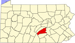
 Map of Perry County, Pennsylvania highlighting Saville Township |
|
 Map of Perry County, Pennsylvania |
|
| Country | United States |
| State | Pennsylvania |
| County | Perry |
| Settled | 1755 |
| Incorporated | 1817 |
| Area | |
| • Total | 46.0 sq mi (119.2 km2) |
| Population (2000) | |
| • Total | 2,204 |
| • Density | 47.9/sq mi (18.5/km2) |
| Time zone | Eastern (EST) (UTC-5) |
| • Summer (DST) | EDT (UTC-4) |
| Area code(s) | 717 |
Saville Township is a second-class township in a mountainous part of Perry County, Pennsylvania, United States. As of the 2010 census, the township had a total population of 2,502. It was founded in 1817, dividing from Tyrone Township while the area was still part of Cumberland County. It is served by two major roads, PA 74, locally called Veterans Way, and PA 17, called the Tuscorara Path. The county office is at 3954 Veterans Way, in Elliottsburg, in the far southern part of the township. The area is overwhelmingly agricultural, with small population centers in Ickesburg and the hamlet of Saville.
The Kochendefer Covered Bridge and Saville Covered Bridge are listed on the National Register of Historic Places.
According to the United States Census Bureau, the township has a total area of 46.0 square miles (119.2 km²), all of it land.
As of the census of 2000, there were 2,204 people, 796 households, and 609 families residing in the township. The population density was 47.9 people per square mile (18.5/km²). There were 984 housing units at an average density of 21.4/sq mi (8.3/km²). The racial makeup of the township was 98.37% White, 0.68% African American, 0.23% Native American, 0.18% Asian, 0.09% from other races, and 0.45% from two or more races. Hispanic or Latino of any race were 0.64% of the population.
...
Wikipedia
