Savannakhet (province)
|
Savannakhet ສະຫວັນນະເຂດ |
|
|---|---|
| Province | |

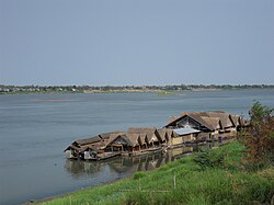
A restaurant on the Mekong
|
|
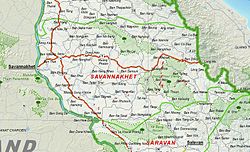
 Map of Savannakhet Province |
|
 Location of Savannakhet Province in Laos |
|
| Coordinates: 16°32′N 105°47′E / 16.54°N 105.78°ECoordinates: 16°32′N 105°47′E / 16.54°N 105.78°E | |
| Country |
|
| Capital | Savannakhet |
| Area | |
| • Total | 21,774 km2 (8,407 sq mi) |
| Population (2015 census) | |
| • Total | 969,697 |
| • Density | 45/km2 (120/sq mi) |
| Time zone | UTC+07 |
| ISO 3166 code | LA-SV |
Savannakhét (Lao:ສະຫວັນນະເຂດ) is a province of Laos. The name derives from Savanh Nakhone ("city of paradise" or "land of fertility suitable for agriculture") the province's original name. It bears the same meaning as Nakhon Sawan, a city in Thailand.
The province is located in the southern part of the country and is the largest province in Laos. It borders Khammouane Province to the north, Quảng Trị and Thừa Thiên–Huế provinces of Vietnam to the east, Salavan Province to the south, and Nakhon Phanom and Mukdahan provinces of Thailand to the west. The Second Thai–Lao Friendship Bridge over the Mekong connects Mukdahan Province in Thailand with Savannakhet in Laos. Its capital, Savannakhet, also known as Kaysone Phomvihane or Muang Khanthabouly is Laos' second most notable city after Vientiane. It forms an important trading post between Thailand and Vietnam.
Along with Bolikhamsai and Khammouane, Savannakhét Province is one of the main tobacco producing areas of Laos. It has numerous natural resources. Sepon is the largest mine in Laos, with reserves of copper and gold.
Prehistoric human occupation is evidenced by the first stone tools in the province, dating back between 100,000 and 12,000 years. The first bronze tools date to 2000 BCE. The region was then the center of the Sikhottabong Kingdom. The much-venerated Pha That Sikhottabong stupa is situated on the grounds of a 19th-century monastery in Thakhek. Sikhottabong was an important kingdom in ancient Indo-China. Its capital was in the north-west of the province, in the present village of Meuang Kabong, on the eastern shores of the Banghiang River, about 10 kilometres (6.2 mi) east of the Mekong. Other centers of the kingdom were in Viang Chan, Khammuan, Nong Khai, and Udon.Khmer Empire ruins dating to AD 553 and 700 have been found at Heuan Hin.
...
Wikipedia
