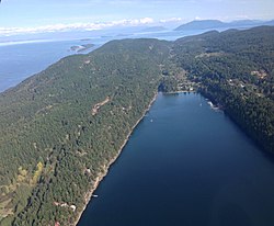
Saturna Island
| Saturna Island | |
|---|---|
| Island | |

South-facing aerial view of Saturna Island
|
|
 The Southern Gulf Islands, including Saturna. |
|
| Coordinates: 48°46′N 123°10′W / 48.767°N 123.167°W | |
| Country | Canada |
| Province | British Columbia |
| Regional District | Capital Regional District |
| Government | |
| • MP | Elizabeth May (Green) |
| • MLA | Gary Holman (NDP) |
| Area | |
| • Land | 31 km2 (12 sq mi) |
| Elevation | 397 m (1,303 ft) |
| Population | |
| • Total | 350 |
| Time zone | PST (UTC−8) |
| • Summer (DST) | PDT (UTC−7) |
| Area code(s) | 250 |
Saturna Island is a mountainous island, about 31 km² (12 sq. miles) in size, in the Southern Gulf Islands chain of British Columbia. It is situated approximately midway between the Lower Mainland of B.C. and Vancouver Island, and is the most easterly of the Gulf Islands. It is surrounded on three sides by the Canada/USA border. To the north is Point Roberts, Washington, and to the east and south are the San Juan Islands. Saturna has a permanent population of around 350, although that number increases significantly during the busy summer season. Approximately half of the island is in the Gulf Islands National Park Reserve (GINPR) that was formed in 2003 from existing provincial parks, an Ecological Reserve, and other Crown land [1].
Parks other than those part of the GINPR are maintained by The Saturna Island Parks & Recreation Commission. They operate over a dozen beach accesses and picnic areas around the island. In addition, they oversee a large community park, Thompson Park, which includes a pebble beach, a picnic shelter, and a nine hole disc golf course.
South Saturna, Winery Grounds with Parks and Recreation Commission Social
Coordinates: 48°47′N 123°09′W / 48.783°N 123.150°W
...
Wikipedia
