Saptashringi
| Saptashrungi Devi Temple | |
|---|---|
 |
|
|
Location in Maharashtra
|
|
| Name | |
| Devanagari | सप्तश्रृंगी |
| Marathi | श्री सप्तश्रृंगी देवस्थान |
| Geography | |
| Coordinates | 20°23′25″N 73°54′31″E / 20.39028°N 73.90861°ECoordinates: 20°23′25″N 73°54′31″E / 20.39028°N 73.90861°E |
| Country | India |
| State | Maharashtra |
| District | Nashik |
| Locale | Vani/Nanduri village |
| Culture | |
| Primary deity | Durga |
| Important festivals | Navratri |
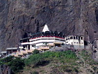
Saptashrungi Saptaśrr̥ṇgī) is a site of Hindu pilgrimage situated 60 kilometres (37 mi) from Nashik in west Indian state of Maharashtra in India. According to Hindu traditions, the goddess Saptashrungi Nivasini dwells within the seven mountain peaks. (Sapta means seven and shrung means peaks.) It is located in Nanduri, Kalwan taluka, a small village near Nashik in India. Devotees visit this place in large numbers every day. The temple is also known popularly as one of the "three and half Shakti Peethas" of Maharashtra. The temple is also one among the 51 Shakti Peethas located on the Indian subcontinent and is a location where one of Sati's (first wife of Lord Shiva) limbs, her right arm is reported to have fallen.
Saptashrungi is a hill range consisting of seven hills locally called Ghads and form part of the Sahyadri Range of hills in Western Ghats. Sahyadri Range is also known as Ajanta Satmala Range and the average height of the peaks is 4,500 feet (1,400 m). The Dhodap, in the center of this mountain range, is the highest peak with an elevation of 4,600 feet (1,400 m), and Saptasrungi is towards its west. There are 108 water bodies (ponds) located in the watershed of these hills, which are called Kundas. Nanduri and Vani are the villages nearest to the temple, which are situated at the foot of the hills. There are many approaches to reach the top of the temple location. The route from Nashik and Vani via Dindori is 39 kilometres (24 mi) and via Pimpalgaon Baswant is 51 kilometres (32 mi). The route via Nadurgaon village is the easiest and is 14 kilometres (8.7 mi) from Vani. It is at a distance of 60 kilometres (37 mi) from Nashik, the district headquarters. The State Highway 17 (Maharashtra) (SH-17) connected with the National Highway 3 (NH 3) links Nashik with the temple site near the villages of Vani and Nanduri. Bus facilities by state transportation are available to reach the temple precincts. The forests in the hills are reported to have medicinal herbs. There is a circumlocutory path used by pilgrims to do parikrama around the temple. This path is in an elevation range between 1,230 metres (4,040 ft) and 1,350 metres (4,430 ft), and is stated to be in steep rock topography. The hills are covered with verdant forests.
...
Wikipedia

