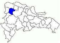
Santiago Rodríguez Province
| Santiago Rodríguez | |
| Province | |
| Country | |
|---|---|
| Capital | San Ignacio de Sabaneta |
| - elevation | 124 m (407 ft) |
| - coordinates | 19°29′0″N 71°21′0″W / 19.48333°N 71.35000°WCoordinates: 19°29′0″N 71°21′0″W / 19.48333°N 71.35000°W |
| Area | 1,111.14 km2 (429 sq mi) |
| Population | 99,044 (2014) |
| Density | 89/km2 (231/sq mi) |
| Province since | 1948 |
| Subdivisions | 3 municipalities 0 municipal districts |
| Congresspersons | 1 Senator (Antonio Cruz Torres) 2 Deputies |
| Timezone | AST (UTC-4) |
| Area code | 1-809 1-829 1-849 |
| ISO 3166-2 | DO-26 |
| Postal Code | 64000 |
|
Location of the Santiago Rodríguez Province
|
|
Santiago Rodríguez (Spanish pronunciation: [sanˈtjaɣo ɾoˈðɾiɣes]) is a province of the Dominican Republic. It was split from Monte Cristi in 1948.
The Santiago Rodríguez province has the Monte Cristi and Valverde provinces to the north, the Santiago province to the east, the San Juan and Elías Piña provinces to the south and the Dajabón province to the west.
Santiago Rodríguez was an officer of the Dominican army in the Dominican War of Independence. He was one of the founders of the city of Sabaneta and an important military leader during the initial stages of the Restoration War (1863–1865)
The province as of June 20, 2006 is divided into the following municipalities (municipios):
The following is a sortable table of the municipalities with population figures as of the 2012 census.
For comparison with the municipalities and municipal districts of other provinces see the list of municipalities and municipal districts of the Dominican Republic.
The Cordillera Central ("Central mountain chain") is found in the southern part of the province, and the Sierra Samba (a chain of low hills) runs across the northern half.
...
Wikipedia

