Santa Barbara, Pangasinan
| Santa Barbara | ||
|---|---|---|
| Municipality | ||
 |
||
|
||
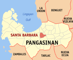
 Map of Pangasinan showing the location of Santa Barbara |
||
| Location within the Philippines | ||
| Coordinates: 16°00′11″N 120°24′03″E / 16.00306°N 120.40083°ECoordinates: 16°00′11″N 120°24′03″E / 16.00306°N 120.40083°E | ||
| Country |
|
|
| Region | Ilocos (Region I) | |
| Province | Pangasinan | |
| District | 3rd district of Pangasinan | |
| Founded | October 30, 1741 | |
| Barangays | 29 | |
| Government | ||
| • Mayor | Carlito S. Zaplan | |
| • Vice Mayor | Joel F. Delos Santos | |
| • Electorate | 44,754 voters (2016 election) | |
| Area | ||
| • Total | 61.37 km2 (23.70 sq mi) | |
| Population (2015 census) | ||
| • Total | 82,012 | |
| • Density | 1,300/km2 (3,500/sq mi) | |
| Time zone | PST (UTC+8) | |
| ZIP code | 2419 | |
| 015538000 | ||
| IDD : area code | +63 (0)75 | |
| Income class | 1st municipal income class | |
| Revenue | ₱ 50,078,319.57 (2016) | |
| Poverty incidence | 12.32 (2012) | |
| Website | www |
|
Santa Barbara is a 1st class municipality in the province of Pangasinan, Philippines. According to the 2015 census, it has a population of 82,012 people.
The town of Santa Barbara lies on a plain terrain in the northern part of the Agno Valley, at the center of Pangasinan. It is just west of the business center of Urdaneta City, with centuries-old mango trees lining the national highway to Santa Barbara. Fifteen kilometers further west is Dagupan City along the Lingayen Gulf, and to its south is the town of Malasiqui and beyond it the City of San Carlos.
Santa Barbara is politically subdivided into 29 barangays.
Elected officials 2016–2019:
Although a large part of Sta. Barbara is fast getting urbanized, the main economic activity remains farming. Rice remains its main crop with 6,662 hectares or close to all its total tillable lands devoted to rice farming. The second most important crop is mango of which the town is famous as the home of age-old Philippine mango seedling nurseries, a veritable home industry in town.
Rice and mango are the only crops that are raised in all its 29 barangays. The third most important crop are a variety of vegetables followed by corn. Legumes and root crops are grown in small quantities.
Their livestock include cattle, carabao, hogs, goats and dogs. They likewise raise native chickens for their food and some poultry farms commercially produce chicken layers and broilers.
Out of the farm produce, Sta. Barbara has developed its own food processing industry that includes the making of rice cakes like latik and suman, nata-de coco making, and pickles from different fruits.
It likewise has a highly developed clay tiles and pottery industry coupled with non-farm based processing industries like candle and soap making and the making of hollow blocks for construction. The town has one industrial plant, the Ginebra San Miguel gin manufacturing plant in Tebag West barangay along the national highway towards Dagupan.
The town’s business and trading center in and around the public market features a variety of wholesale and retail and other services establishments from farm inputs to construction materials. The market serves as the place where its people buy their needs and sell their produce. Transportation between the commercial center and the many barangays is served by a large fleet of individually owned tricycles.
...
Wikipedia


