Santa Ana, Cagayan
| Santa Ana | ||
|---|---|---|
| Municipality | ||

View of Santa Ana coast from Mount Cagua
|
||
|
||
| Nickname(s): The Game Fishing Mecca of the Philippines | ||
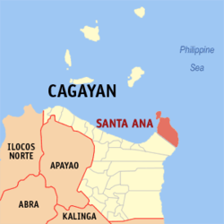
 Map of Cagayan showing the location of Santa Ana |
||
| Location within the Philippines | ||
| Coordinates: 18°28′N 122°09′E / 18.47°N 122.15°ECoordinates: 18°28′N 122°09′E / 18.47°N 122.15°E | ||
| Country | Philippines | |
| Region | Cagayan Valley (Region II) | |
| Province | Cagayan | |
| District | 1st District | |
| Founded | October 21, 1949 | |
| Barangays | 16 | |
| Government | ||
| • Mayor | Darwin A. Tobias | |
| Area | ||
| • Total | 441.30 km2 (170.39 sq mi) | |
| Population (2015 census) | ||
| • Total | 32,906 | |
| • Density | 75/km2 (190/sq mi) | |
| Time zone | PST (UTC+8) | |
| ZIP code | 3514 | |
| IDD : area code | +63 (0)78 | |
| Income class | 2nd class | |
Santa Ana is a second-class municipality in the province of Cagayan, Philippines. According to the 2015 census, it has a population of 32,906 people.
The municipality is on the north-easternmost point of Luzon and includes Palaui Island as well. It is the home of the Cagayan Special Economic Zone and the Naval Base Camilo Osias (Naval Operating Base San Vicente) in Barangay San Vicente.
Santa Ana is politically subdivided into 16 barangays, listed here with the 2015 population.
The first inhabitants were the Negritos and "hacheros" (woodcutters) under Don Julián Astigarraga (Capitan Vasco 1854-1901) of Aparri. Some fishermen from Minanga ( a barrio of Gonzaga) came and settled in Palawig. In 1891, Felipe Agarpao with some settlers organized a "gimong" (society) called "Inanama." The purpose of the organisation was to acquire and occupy lands around the place. That same year, Briccio Campañano of Lapog, Ilocos Sur together with some others from Ilocos came to Palawig to apply for homesteads in the sitio of Marede. These settlers organized another "gimong" called "Dagupan."
In 1900, the woodcutters from Aparri led by Don Julian Astigarraga arrived by the first boat. Thus, began the clearing of settlements.
From 1919 to 1935 several group of settlers from the Ilocos Region came to claim lands aboard virays (light seagoing boats). The once-forested areas were accessible only via rivers and the sea. Before reaching the settlements in the northern and eastern portions, they had to navigate through Palawig River.
The name Palawig was coined from the local term pasawig, meaning mouth of the river.
In 1935, the gimongs "Inanama and Dagupan" fused into one called "Da Inanama," headed by Navarro, they began to work for the separation of Palawig as a municipality independent from Gonzaga. Their application was held in abeyance because their population did not meet the needed number required by law. The move was suspended in 1941 and when World War II broke out the move was not carried out.
...
Wikipedia


