Sanmenxia Reservoir
| Sanmenxia Dam | |
|---|---|
 |
|
|
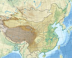
Location of Sanmenxia Dam in China
|
|
| Location | Sanmenxia |
| Coordinates | 34°49′46″N 111°20′41″E / 34.82944°N 111.34472°ECoordinates: 34°49′46″N 111°20′41″E / 34.82944°N 111.34472°E |
| Construction began | 1957 |
| Opening date | 1960 |
| Dam and spillways | |
| Type of dam | Gravity |
| Impounds | Yellow River |
| Height | 106 m (348 ft) |
| Length | 713 m (2,339 ft) |
| Reservoir | |
| Creates | Sanmenxia Reservoir |
| Total capacity | 16,200,000,000 m3 (13,133,554 acre·ft) |
| Catchment area | 688,400 km2 (265,793 sq mi) |
| Surface area | 2,350 km2 (907 sq mi) |
| Maximum length | 246 km (153 mi) |
| Power station | |
| Commission date | 1973–1975 |
| Turbines | 5 x 50 MW, 2 x 75 MW Francis-type |
| Installed capacity | 400 MW |
The Sanmenxia Dam is a concrete gravity dam on the middle-reaches of the Yellow River near Sanmenxia Gorge on the border between Shanxi province and Henan Province, China. The dam is multi-purpose and was constructed for flood and ice control along with irrigation, hydroelectric power generation and navigation. Construction began in 1957 and was completed in 1960. It is the first major water control project on the Yellow River and was viewed as a major achievement of the new People's Republic of China. Subsequently, its image was printed on the country's bank notes. However, due to sediment accumulation in the reservoir, the dam later had to be re-engineered and renovated. The effects from sediment, which include flooding upstream, have placed the dam at the center of controversy and criticism-related arrests by the Chinese government.
In response to centuries of flooding on the Yellow River, engineers initially proposed the Sanmenxia Dam in early 1935. In 1954, the Yellow River Planning Board was established and oversaw a survey of the river with help from Soviet engineers. The Soviet engineers recommended a dam at the Sanmenxia site. Original plans for the dam called for a maximum reservoir level 360 m (1,181 ft) above sea level (ASL). This would have required the relocation of 870,000 people and the flooding of 3,500 km2 (1,351 sq mi). The design was revised to a maximum level of 340 m (1,115 ft) ASL which required the relocation of 400,000 people and flooded much less area. In 1955 the Comprehensive River Basin Planning Report officially proposed the project. The report was submitted to the National People's Congress and swiftly approved that same year while preliminary construction began soon after. Under Soviet Union supervision, construction ceremoniously began on 13 April 1957. Construction on the left-bank cofferdam began in June 1957 and excavation was completed a year later along with the pouring of the left-bank foundation. In October 1958, construction on the right-bank cofferdam was initiated and the river was closed by November 1958. In June 1960, the reservoir was at full pool and the dam crest reached its design elevation of 353 m (1,158 ft) ASL in April 1961. The dam's generators were commissioned between 1973 and 1975. The dam was the first major water project on the Yellow River and constructed with manual labor. Upon completion, it was hailed as an engineering success for the new republic and its image was printed on Chinese banknotes.
...
Wikipedia

