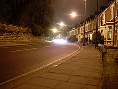
Sandyford, Newcastle upon Tyne
| Sandyford | |
|---|---|
 Sandyford Road, the NW boundary of Sandyford (on the right) |
|
| Sandyford shown within Tyne and Wear | |
| OS grid reference | NZ257658 |
| • London | 242 miles (389 km) |
| Metropolitan borough | |
| Metropolitan county | |
| Region | |
| Country | England |
| Sovereign state | United Kingdom |
| Post town | NEWCASTLE UPON TYNE |
| Postcode district | NE2 |
| Dialling code | 0191 |
| Police | Northumbria |
| Fire | Tyne and Wear |
| Ambulance | North East |
| EU Parliament | North East England |
| UK Parliament | |
Sandyford is a district of Newcastle upon Tyne, located in the east end of the city. It is bordered by the City Centre and the districts of Jesmond and Heaton.
Sandyford is a largely student-dominated area of Newcastle upon Tyne because of its proximity to the two universities in the city: Newcastle University and Northumbria University.
It is similar to both Heaton and Jesmond in terms of street layout and architecture. The housing stock is mostly of red brick Victorian terraced housing, and many of these are Tyneside flats. Towards the south of the area are some light industrial businesses, and towards the southeast, the residential streets run steeply down towards Jesmond Dene. Sandyford is located at the end of Jesmond's Osborne Road and is serviced by the Jesmond Metro station.
Sandyford is home to FPP Brand Communications, the European award winning communications agency, and several local businesses, including a shop, an Italian bistro, an Italian restaurant, three sandwich shops, an award winning fish'n'chip shop, a Chinese takeaway, a Post Office and a car garage. The area also hosts four hairdressers.
...
Wikipedia

