Sandgate, Queensland
|
Sandgate Brisbane, Queensland |
|||||||||||||||
|---|---|---|---|---|---|---|---|---|---|---|---|---|---|---|---|

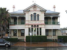
Former Sandgate post office
(now The Chandelier Pub & Diner) |
|||||||||||||||
| Population | 4,626 (2011 census) | ||||||||||||||
| • Density | 1,076/km2 (2,790/sq mi) | ||||||||||||||
| Established | 1853 | ||||||||||||||
| Postcode(s) | 4017 | ||||||||||||||
| Area | 4.3 km2 (1.7 sq mi) | ||||||||||||||
| LGA(s) |
City of Brisbane (Deagon Ward) |
||||||||||||||
| State electorate(s) | Sandgate | ||||||||||||||
| Federal Division(s) | Lilley | ||||||||||||||
|
|||||||||||||||
Sandgate is a coastal suburb in Brisbane, Australia, 16 kilometres (9.9 mi) north of the Brisbane CBD. The town became a popular escape for the people of Brisbane in the early 20th century. At the 2011 Australian Census the suburb recorded a population of 4,626.
In the 2011 census, the population of Sandgate was 4,626, 51.4% female and 48.6% male. The median age of the Sandgate population was 43 years, 6 years above the Australian median.
77.8% of people living in Sandgate were born in Australia, compared to the national average of 69.8%; the next most common countries of birth were England 5.9%, New Zealand 3.7%, Scotland 0.8%, Ireland 0.6%, Philippines 0.5%. 92.1% of people spoke only English at home; the next most common languages were 0.5% German, 0.5% Japanese, 0.4% French, 0.3% Filipino, 0.3% Italian.
Sandgate is situated on the coastline, along Bramble Bay. It is connected to the Queensland Rail City network. The western border of the suburb is marked by the Gateway Motorway. A large section to the west of the suburb is known as the Deagon Wetlands which is part of the North East Wetlands of Brisbane.
The name of the area may have been inspired by Sandgate on the coast of county Kent, England by James Burnett, an early surveyor in the region.Sandgate in Kent had a military camp, Shorncliffe Camp, on top of the cliffs adjacent to it. Sandgate in Brisbane also has an adjacent suburb called Shorncliffe.
It is recorded that the Turrbul people, who long inhabited the seashore, the creeks and lagoons, in what we know as the locality of Nudgee Beach to the Pine River, were a branch of the clan of the Yugarabul speaking people. This larger clan inhabited the area from North Brisbane and along the coastline of Nudgee, Sandgate to Caboolture. In their language the local Turrbal clan called their coastal land "Warra" – "an open sheet of water". This land we call Shorncliffe, Sandgate and Brighton. Their existence depended upon their knowledge of the seasons and their surroundings. Spears, nullas and boomerangs were used in hunting and woven nets for fishing.
Land in Sandgate became available in 1853, allowing a small seaside settlement to develop. By 1874, coach services connected Sandgate to Brisbane. The coming of the railway in 1882 promoted more rapid development of the Sandgate area. Travel to Brisbane by train could be completed in less than half an hour. On 29 April 1880, Sandgate was proclaimed a municipality known as the Borough of Sandgate. The Local Authorities Act 1902 replaced all Divisions and Boroughs with Towns and Shires, creating the Town of Sandgate on 31 March 1903. This new status meant a town council was formed to guide the development of the local area. Initially, the council chambers were located in Shorncliffe. However, following a fire which destroyed the council chambers in 1910, a much larger town hall was opened in 1911. The Sandgate Town Hall was extensively renovated in 2011 to mark the 100th anniversary of the hall.
...
Wikipedia
