San Salvador Island
|
San Salvador Island Guanahani Watlings Island |
||
|---|---|---|
| Island and District | ||

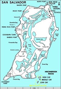
Map of San Salvador Island
|
||
|
||
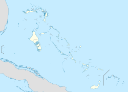
| Coordinates: 24°06′N 74°29′W / 24.100°N 74.483°WCoordinates: 24°06′N 74°29′W / 24.100°N 74.483°W | ||
| Country |
|
|
| Island | San Salvador | |
| District | San Salvador | |
| Area | ||
| • Total | 163 km2 (63 sq mi) | |
| Population (2010) | ||
| • Total | 930 | |
| Time zone | Eastern Time Zone (UTC-5) | |
| Area code(s) | 242 | |
San Salvador Island (known as Watlings Island from the 1680s until 1925) is an island and district of the Bahamas. It is widely believed that during Christopher Columbus' first expedition to the New World, San Salvador Island was the first land he sighted and visited on 12 October 1492; he named it San Salvador after Christ the Saviour. Columbus' records indicate that the native Lucayan inhabitants of the territory, who called their island Guanahani, were "sweet and gentle".
When he made landfall on the tiny island of San Salvador in 1492, Columbus thought he had reached the East Indies. This was precisely his quest- to find an all-water route to the orient so that European traders, who traded precious spices, could avoid paying tribute to the Middle Eastern middlemen who skimmed profits off overland trading ventures. The island was called Guanahani by the Natives of the island, and the name was promptly changed following Spanish colonization. In the 17th century, San Salvador was settled by an English Buccaneer, John Watling (alternately referred to as George Watling), who gave the island its alternative historical name. The United Kingdom gained control of what are now the Bahamas in the early 18th century. In 1925 the name "San Salvador" was officially transferred from another place, now called Cat Island, and given to "Watlings Island," based on historians believing this was a more likely match for Columbus' description of Guanahani. Advocates of Watling's Island included H. Major, the map-custodian of the British Museum; and the geographer Clements R. Markham, as well as the American sea historian Samuel E. Morison.
The American Fr. Chrysostom Schreiner OSB, the first Catholic priest permanently assigned to the Bahamas, served primarily at St. Francis Xavier in Nassau. A history enthusiast, he researched Columbus' landing extensively and promoted San Salvador as the correct landing site. In retirement, Fr. Chrysostom relocated to San Salvador, where he died on 3 Jan 1928. He was buried the next day. Memorial Masses were celebrated in Nassau; Collegeville, Minnesota (the site of St. John's Abbey, his monastery); and New York. Cardinal Hayes referred to him as the Catholic Apostle to the Bahamas; he was a unique religious presence on the islands. His tomb can still be seen on San Salvador.
...
Wikipedia


