San Remigio, Antique
| San Remigio | |
|---|---|
| Municipality | |

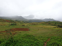
San Remigio landscape
|
|
 Location within Antique province |
|
| Location within the Philippines | |
| Coordinates: 10°53′N 122°07′E / 10.88°N 122.12°ECoordinates: 10°53′N 122°07′E / 10.88°N 122.12°E | |
| Country | Philippines |
| Region | Western Visayas (Region VI) |
| Province | Antique |
| District | Lone district |
| Founded | July 1, 1864 |
| Barangays | 45 (see Barangays) |
| Government | |
| • Type | Sangguniang Bayan |
| • Mayor | Glenn V. Cabigunda |
| Area | |
| • Total | 406.98 km2 (157.14 sq mi) |
| Population (2015 census) | |
| • Total | 31,935 |
| • Density | 78/km2 (200/sq mi) |
| • Voter (2016) | 17,572 |
| Time zone | PST (UTC+8) |
| ZIP code | 5714 |
| IDD : area code | +63 (0)36 |
| Income class | 3rd class |
| PSGC | 060614000 |
| Website | elgu |
San Remigio, officially the Municipality of San Remigio (Karay-a: Banwa kang San Remigio; Hiligaynon: Banwa sang San Remigio; Filipino: Bayan ng San Remigio), is a municipality in the province of Antique in the Western Visayas (Region VI) of the Philippines. The population was 31,935 at the 2015 census. In the 2016 electoral roll, it had 17,572 registered voters.
San Remigio is 21 kilometres (13 mi) north-east from the provincial capital, San Jose de Buenavista.
San Remigio is located at 10°53′N 122°07′E / 10.88°N 122.12°E.
According to the Philippine Statistics Authority, the municipality has a land area of 406.98 square kilometres (157.14 sq mi) constituting 14.91% of the 2,729.17-square-kilometre- (1,053.74 sq mi) total area of Antique.
Almost 70% of its land area are mountainous and the remaining 30% comprise the flat lowland and rolling hills.
Agriculture occupies 47.815 square kilometres (18.461 sq mi) of land. Of this, 44.37 square kilometres (17.13 sq mi) is for food crops, 1.035 square kilometres (0.400 sq mi) is for permanent crops, and 2.41 square kilometres (0.93 sq mi) for commercial crops.
...
Wikipedia

