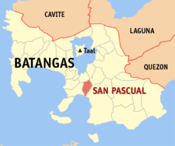
San Pascual, Batangas
| San Pascual | |
|---|---|
| Municipality | |
 Location within Batangas province |
|
| Location within the Philippines | |
| Coordinates: 13°48′N 121°02′E / 13.8°N 121.03°ECoordinates: 13°48′N 121°02′E / 13.8°N 121.03°E | |
| Country | Philippines |
| Region | Calabarzon (Region IV-A) |
| Province | Batangas |
| District | 2nd District |
| Founded | 1932 |
| Barangays | 29 (see Barangays) |
| Government | |
| • Type | Sangguniang Bayan |
| • Mayor | Roanna Conti (Liberal) |
| • Vice Mayor | Antonio Dimayuga (NPC) |
| • Councilors |
List
|
| Area | |
| • Total | 50.70 km2 (19.58 sq mi) |
| Population (2015 census) | |
| • Total | 65,424 |
| • Density | 1,300/km2 (3,300/sq mi) |
| • Voter (2016) | 38,336 |
| Time zone | PST (UTC+8) |
| ZIP code | 4204 |
| IDD : area code | +63 (0)43 |
| Income class | 1st class |
| PSGC | 041026000 |
San Pascual, officially the Municipality of San Pascual (Filipino: Bayan ng San Pascual), is a municipality in the province of Batangas in the Calabarzon (Region IV-A) of the Philippines. The population was 65,424 at the 2015 census. In the 2016 electoral roll, it had 38,336 registered voters.
San Pascual was historically part of Bauan and was known as "Lagnas". It became an independent municipality in 1969. The municipality is adjacent to Batangas City, along Batangas Bay. The town is home to an oil refinery and chemical plants as well as other industrial and commercial establishments.
On June 3, 2011, a hailstorm tornado devastated San Pascual and other nearby municipalities such as Bauan and Taal.
San Pascual is located at 13°48′N 121°02′E / 13.8°N 121.03°E.
According to the Philippine Statistics Authority, the municipality has a land area of 50.70 square kilometres (19.58 sq mi) constituting 1.63% of the 3,119.75-square-kilometre- (1,204.54 sq mi) total area of Batangas.
San Pascual is politically subdivided into 29 barangays.
...
Wikipedia

