San Mariano, Isabela
| San Mariano | ||
|---|---|---|
| Municipality | ||

Aerial view of San Mariano, with Benito Soliven in the foreground
|
||
|
||
| Nickname(s): Rice Bowl of Isabela | ||
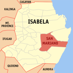
 Map of Isabela showing the location of San Mariano |
||
| Location within the Philippines | ||
| Coordinates: 16°59′N 122°01′E / 16.98°N 122.02°ECoordinates: 16°59′N 122°01′E / 16.98°N 122.02°E | ||
| Country | Philippines | |
| Region | Cagayan Valley (Region II) | |
| Province | Isabela | |
| District | 2nd District of Isabela | |
| Founded | 1954 | |
| Barangays | 36 | |
| Government | ||
| • Mayor | Edgar Go (Nacionalista Party) | |
| • Vice Mayor | Dean Anthony G. Domalanta | |
| • Electorate | 28,562 voters (2016 election) | |
| Area | ||
| • Total | 1,469.50 km2 (567.38 sq mi) | |
| Population (2015 census) | ||
| • Total | 55,370 | |
| • Density | 38/km2 (98/sq mi) | |
| Time zone | PST (UTC+8) | |
| ZIP code | 3332 | |
| 023131000 | ||
| IDD : area code | +63 (0)78 | |
| Income class | 1st municipal income class | |
| Revenue | ₱ 15,081,968.97 (2016) | |
| Poverty incidence | 30.61 (2012) | |
| Website | www |
|
San Mariano is a 1st class municipality in the province of Isabela, Philippines. According to the 2015 census, it has a population of 55,370 people.
It is also a suburb of neighboring Ilagan, the provincial capital.
San Mariano has a total land area of 146,950 hectares (363,100 acres). It constitutes 13.78 percent of the total land area of the Province, and is the province's largest and the country's third largest municipality.
The municipality lies in the eastern part of the Province of Isabela. It is bounded on the north by the Ilagan City, on the east by the Municipality of Palanan, on the south by the Municipality of San Guillermo and on the west by the Municipality of Benito Soliven. It is approximately 404 kilometres (251 mi) from Metro Manila and 46 kilometres (29 mi) from Ilagan City, the provincial capital.
Today, San Mariano is continuously being developed, road constructions and other infrastructure project is already being implemented.
San Mariano is politically subdivided into 36 barangays.
Of the total land area of the municipality, built-up area constitutes 1,268 hectares or 0.86 percent with the Poblacion as the largest and most densely populated built-up area. Open grasslands occupy a total area of approximately 20,700 hectares representing about 14.09 percent. Generally, the open grasslands are flanked by either agricultural areas or forest areas. Vast forest areas of the municipality are mostly found at its eastern portion, which covers about 53.39 percent or an approximated area of 78,450.50 hectares. About 29,264 hectares or 19.91 percent are presently devoted to extensive agricultural activities with corn, rice and bananas as the major crops. Water bodies, including banks, buffer or salvage zones occupy an estimated 11.58 percent while existing roads and streets cover 2.17 percent of the municipality’s total area.
Legend has it that San Mariano was once a barrio of Ilagan, the capital city of the province of Isabela. It was first named as Angela in reference to Mariano Kalingog whose family was one of the foremost settlers of the place. Angela was drowned while she was washing clothes along the Pinacanauan River. The incident brought grief to the people and her husband Mariano who also died some years later. Since then, this village teeming with fish and lush trees was known as San Mariano.
...
Wikipedia


