San Juan Islands dispute
| Pig War | |||||||
|---|---|---|---|---|---|---|---|
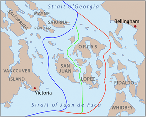
 Proposed boundaries:
Through Haro Strait, favored by the US
Through Rosario Strait, favored by Britain
Through San Juan Channel, compromise proposal
The lines are as shown on maps of the time. The modern boundary follows straight line segments and roughly follows the blue line. The modern eastern boundary of San Juan County roughly follows the red line. |
|||||||
|
|||||||
| Belligerents | |||||||
|
|
|
||||||
| Commanders and leaders | |||||||
| Colonel Silas Casey, Captain George Pickett | Rear Admiral R. L. Baynes | ||||||
| Strength | |||||||
| 461 combatants, 14 cannon | 2,140 combatants; 5 warships mounting 70 cannon | ||||||
The Pig War was a confrontation in 1859 between the United States and United Kingdom over the British–U.S. border in the San Juan Islands, between Vancouver Island and the mainland. The Pig War, so called because it was triggered by the shooting of a pig, is also called the Pig Episode, the Pig and Potato War, the San Juan Boundary Dispute or the Northwestern Boundary Dispute. With no shots exchanged and no human casualties, this dispute was a bloodless conflict.
The Oregon Treaty of June 15, 1846, resolved the Oregon boundary dispute by dividing the Oregon Country/Columbia District between the United States and Britain "along the forty-ninth parallel of north latitude to the middle of the channel which separates the continent from Vancouver Island, and thence southerly through the middle of the said channel, and of the Strait of Juan de Fuca, to the Pacific Ocean"."
However, there are actually two straits that could be called the middle of the channel: Haro Strait, along the west side of the San Juan Islands; and Rosario Strait, along the east side.
In 1846, there was still some uncertainty about the geography of the region. The most commonly available maps were those of George Vancouver, published in 1798, and of Charles Wilkes, published in 1845. In both cases the maps are unclear in the vicinity of the southeastern coast of Vancouver Island and the Gulf Islands. As a result, Haro Strait is not fully clear either.
...
Wikipedia
