San Jose, Northern Samar
| San Jose | |
|---|---|
| Municipality | |
| Nickname(s): Carangian | |
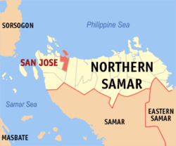
 Map of Northern Samar showing the location of San Jose |
|
| Location within the Philippines | |
| Coordinates: 12°31′52″N 124°29′13″E / 12.531°N 124.487°ECoordinates: 12°31′52″N 124°29′13″E / 12.531°N 124.487°E | |
| Country |
|
| Region | Eastern Visayas (Region VIII) |
| Province | Northern Samar |
| District | District of Northern Samar |
| Established | July 25, 1949 |
| Barangays | 16 |
| Government | |
| • Mayor | Clarence Evaristo Dato |
| • Vice-Mayor | Jose Agripino Ballesta |
| Area | |
| • Total | 29.85 km2 (11.53 sq mi) |
| Population (2015) | |
| • Total | 17,561 |
| • Density | 590/km2 (1,500/sq mi) |
| Time zone | PST (UTC+8) |
| ZIP code | 6402 |
| Dialing code | 55 |
| Income class | 5th |
San Jose is a fifth class municipality in the Province of Northern Samar, Philippines. It is located at the north central part of the province, about 19 kilometres (12 mi) west of Catarman, the provincial capital, and about 30 kilometres (19 mi) east of Allen, where the ferry terminal is which connects the islands of Luzon, Samar, Leyte, and Mindanao via the Pan-Philippine Highway (formerly the Maharlika Highway). It is approximately 150 kilometres (93 mi) north-north-east of Tacloban City, the Regional Center of the Eastern Visayas. According to the 2015 census, it has a population of 17,561 people.
Politically, the municipality is bounded on the north by the Philippine Sea, on the east by the Municipality of Bobon, on the south by the Municipality of Victoria and on the west by the Municipality of Rosario.
San Jose's total land area of 2,985 hectares (7,380 acres) is generally underlain by well-bedded and moderately undulating terrain. The rock unit is probably part of the Mawo Volcanics, which is widespread in Northern Samar. The terrain is diversely oriented with inclination angles ranging from 10 degrees to 14 degrees. In the surveyed area, mangrove swamps dominate the western part of the municipality which extends to its northern coastline. In fact, more than half of the land area in the town proper, which is located at the northern coastline of the municipality are reclaimed lands from these swamplands.
Being a coastal town, it has several islets within its municipal waters off its northern coast: Cabaungon (or Cabanongan) Grande, Cabaungon Pequiño, Tandang, Pangilala, Puropangdan, Matungko, and Maghungaw. They are plentiful in fishes, crustaceans, and other marine products. These islands along the coast of San Jose are protected as part of the Biri Larosa Protected Landscape and Seascape.
The municipality is in a valley bounded on the east by the Palusong Mountain Range moving south and on the west by the Hitaasan Mountain Range. The land is generally alluvial flat and swamplands which has an elevation of less than 10 meters above sea level, while going south, south easterly, the physiography abruptly rises to moderately rugged hills with a peak of 68 metres (223 ft). The drainage system in the area generally flows north-east towards Carangian Channel. Vegetation in this area generally consists of mangrove trees and shrubs, cogonal growth, and coconuts. The flat areas are planted with rice, corn and coconuts.
...
Wikipedia

