San Jon, New Mexico
| San Jon, New Mexico | |
|---|---|
| Village | |

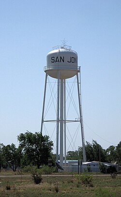
Water tower in San Jon
|
|
 Location of San Jon, New Mexico |
|
| Location in the United States | |
| Coordinates: 35°6′27″N 103°19′49″W / 35.10750°N 103.33028°WCoordinates: 35°6′27″N 103°19′49″W / 35.10750°N 103.33028°W | |
| Country |
|
| State |
|
| County | Quay |
| Area | |
| • Total | 2.6 sq mi (6.8 km2) |
| • Land | 2.6 sq mi (6.8 km2) |
| • Water | 0.0 sq mi (0.0 km2) |
| Elevation | 4,032 ft (1,229 m) |
| Population (2000) | |
| • Total | 306 |
| • Density | 116.5/sq mi (45.0/km2) |
| Time zone | Mountain (MST) (UTC-7) |
| • Summer (DST) | MDT (UTC-6) |
| ZIP codes | 88411, 88434 |
| Area code(s) | 575 |
| FIPS code | 35-68150 |
| GNIS feature ID | 0894426 |
San Jon ("San Hone") is a village in Quay County, New Mexico, United States. The population was 306 at the 2000 census.
The village was founded in 1902 and grew after the arrival of the railroad in 1904. It was once an important local commercial center and stop on U.S. Route 66 and home to numerous tourist-oriented businesses, such as gasoline service stations, cafes and motels. However, when Interstate 40 bypassed the village in 1981, the local economy went into a decline, leading most of those businesses to shut down. Today, only one motel is still in operation and all of the gas stations and dining establishments are centered around the I-40 interchange on the north side of town.
San Jon is located at 35°6′27″N 103°19′49″W / 35.10750°N 103.33028°W (35.107614, -103.330396).
According to the United States Census Bureau, the village has a total area of 2.6 square miles (6.7 km2), all land.
The village is located on I-40 at New Mexico State Highway 469 and is east of Tucumcari.
Northern escarpment of the Llano Estacado, located 14 km south of San Jon, Eastern New Mexico
Road cut south of San Jon on New Mexico State Highway 469 as it crosses the caprock escarpment at the northern edge of the Llano Estacado.
View of San Jon, looking north from the caprock escarpment of the Llano Estacado
...
Wikipedia

