San Fernando, CA
| San Fernando, California | ||
|---|---|---|
| City | ||
| City of San Fernando | ||
|
||
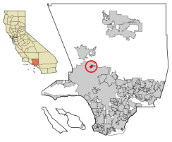
 Location of San Fernando in Los Angeles County, California |
||
| Location in the United States | ||
| Coordinates: 34°17′14″N 118°26′20″W / 34.28722°N 118.43889°WCoordinates: 34°17′14″N 118°26′20″W / 34.28722°N 118.43889°W | ||
| Country | ||
| State |
|
|
| County |
|
|
| Incorporated | August 31, 1911 | |
| Government | ||
| • City council |
Mayor Robert Gonzales Mayor Pro-Tem Sylvia Ballin Antonio Lopez Jaime Soto Robert Gonzales |
|
| Area | ||
| • Total | 2.374 sq mi (6.149 km2) | |
| • Land | 2.374 sq mi (6.149 km2) | |
| • Water | 0 sq mi (0 km2) 0% | |
| Elevation | 1,070 ft (326 m) | |
| Population (2010) | ||
| • Total | 23,645 | |
| • Density | 10,000/sq mi (3,800/km2) | |
| Time zone | PST (UTC-8) | |
| • Summer (DST) | PDT (UTC-7) | |
| ZIP Code | 91340, 91341, 91342, 91344-91346 | |
| Area code(s) | 818, 747 | |
| FIPS code | 06-66140 | |
| GNIS feature IDs | 1652786, 2411785 | |
| Website | www |
|
San Fernando is a city located in the San Fernando Valley, in the northwestern region of Los Angeles County, California. It is completely surrounded by the City of Los Angeles.
The city was named for the nearby Mission San Fernando Rey de España, and was part of the Mexican land grant of Rancho Ex-Mission San Fernando. In 1874 Charles Maclay, San Fernando founder, bought 56,000 acres (227 km2) of the Rancho. In 1882, cousins George K. Porter and Benjamin F. Porter of future Porter Ranch each received one-third of the total land. In 1885, Maclay founded the Maclay School of Theology, a Methodist seminary in his newly founded town of San Fernando. After his death it became an affiliate and moved to the campus of the University of Southern California and then the Claremont School of Theology.
While most of the towns in the surrounding San Fernando Valley agreed to annexation by Los Angeles in the 1910s, eager to tap the bountiful water supply provided by the newly opened Los Angeles Aqueduct, San Fernando's abundant groundwater supplies allowed it to remain a separate city. Even as the San Fernando Valley transformed itself from an agricultural area to a suburban one in the decades after World War II, San Fernando retained its independence.
As with much of the San Fernando Valley east of the San Diego Freeway, the city of San Fernando has seen a significant demographic shift in recent years; declining birth-rates, an aging population of middle-class caucasians, who once dominated the area in the 1950s, has contributed to the movement into other parts of the San Fernando Valley. There has also been movement into the Santa Clarita and Antelope Valleys to the north. Income levels have declined as a result. Latinos became the majority population. Since late 2004, the city has been going through a series of planning development projects, that can be defined as gentrification.
...
Wikipedia


