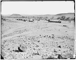
San Felipe Pueblo
| San Felipe Pueblo, New Mexico | |
|---|---|
| CDP | |

San Felipe Pueblo
|
|
| Nickname(s): Katishtya | |
 Location of San Felipe Pueblo, New Mexico |
|
| Location in the United States | |
| Coordinates: 35°25′37″N 106°26′37″W / 35.42694°N 106.44361°WCoordinates: 35°25′37″N 106°26′37″W / 35.42694°N 106.44361°W | |
| Country | United States |
| State | New Mexico |
| County | Sandoval |
| Area | |
| • Total | 12.2 sq mi (31.6 km2) |
| • Land | 11.9 sq mi (30.8 km2) |
| • Water | 0.3 sq mi (0.8 km2) |
| Elevation | 5,131 ft (1,564 m) |
| Population (American Community Survey, 2012) | |
| • Total | 2,678 |
| • Density | 174.6/sq mi (67.4/km2) |
| Time zone | Mountain (MST) (UTC-7) |
| • Summer (DST) | MDT (UTC-6) |
| Area code(s) | 505 |
| FIPS code | 35-67450 |
| GNIS feature ID | 0928802 |
San Felipe Pueblo (Eastern Keres: Katishtya) is a census-designated place (CDP) in Sandoval County, New Mexico, United States and is located 10 miles (16 km) north of Bernalillo. As of the 2000 census, the CDP population was 2,080. It is part of the Albuquerque Metropolitan Statistical Area. The Pueblo, founded in 1706, comprises Native Americans who speak an eastern dialect of the Keresan languages.
The Pueblo celebrates the annual Feast of St. Philip on May 1, when hundreds of pueblo people participate in traditional corn dances.
Today, the tribe operates Casino Hollywood, just off Interstate 25.
San Felipe Pueblo is located at 35°25′37″N 106°26′37″W / 35.42694°N 106.44361°W (35.426985, -106.443593).
According to the United States Census Bureau, the CDP has a total area of 12.2 square miles (31.6 km²), of which, 11.9 square miles (30.8 km²) of it is land and 0.3 square miles (0.8 km²) of it (2.46%) is water.
...
Wikipedia

