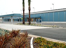
San Bernardino International Airport
| San Bernardino International Airport | |||||||||||
|---|---|---|---|---|---|---|---|---|---|---|---|
 |
|||||||||||
 |
|||||||||||
| Summary | |||||||||||
| Airport type | Public | ||||||||||
| Owner | San Bernardino International Airport Authority (SBIA) | ||||||||||
| Operator | SBIA | ||||||||||
| Serves | San Bernardino / Inland Empire | ||||||||||
| Location | San Bernardino, California, United States | ||||||||||
| Elevation AMSL | 1,159 ft / 353 m | ||||||||||
| Coordinates | 34°05′43″N 117°14′06″W / 34.095278°N 117.235°WCoordinates: 34°05′43″N 117°14′06″W / 34.095278°N 117.235°W | ||||||||||
| Website | sbdairport |
||||||||||
| Runways | |||||||||||
|
|||||||||||
San Bernardino International Airport (IATA: SBD, ICAO: KSBD, FAA LID: SBD) (SBIA) is a public airport located less than two miles (3 km) southeast of the city center of San Bernardino, California, in San Bernardino County, California, USA. The airport covers 1,329 acres (538 ha) and has one runway. The facility is currently operating as a general aviation and cargo airport located on the former site of Norton Air Force Base, which was built as the San Bernardino Air Depot in 1942 and which was decommissioned in the 1990s. A non-federal control tower (NFCT) began operation on November 9, 2008, and is operated under contract by SERCO company personnel.
The air base opened shortly after the attacks on Pearl Harbor to protect the southern California area. Norton was placed on the Department of Defense's base closure list in 1989 (the same year that the DoD signed the Federal Facilities Agreement with the EPA).
The closure was cited as due to environmental wastes, inadequate facilities, and air traffic congestion. The last of the facilities on the base were closed in 1995.
Most parts of San Bernardino International Airport were completed in 2011. However, a customs facility is still under construction. San Bernardino International Airport was built to conform to aviation-demand modeling and allocations performed as part of the 2008 Regional Transportation Plan (R.T.P.) of the Southern California Association of Governments (SCAG), the Metropolitan Planning Organization for San Bernardino, Los Angeles, Riverside, Ventura, Imperial, and Orange counties.
The 2008 R.T.P. projects 9.4 million passengers and 1,290,000 tons of air cargo at San Bernardino International Airport in 2035 with improved ground access provided, in part, by high-speed rail. The California High-Speed Rail Authority is currently performing alternatives analysis regarding the Los Angeles-to-San Diego segment, which includes, along the I-215 alignment, an optional station location at Rialto Avenue and E Street in the city of San Bernardino. The 2008 R.T.P states, "The high speed, reliability, and predictability of high-speed airport access will be needed to overcome mounting and increasingly unpredictable traffic congestion (on area freeways)."
...
Wikipedia
