San Andreas Fault Zone
| San Andreas Fault | |
|---|---|

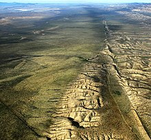
Aerial photo of the San Andreas Fault
|
|

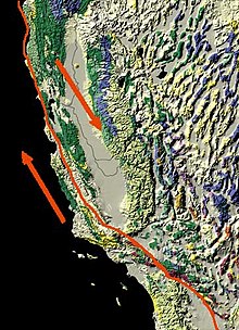
Map of the San Andreas Fault
showing relative motion |
|
| Etymology | San Andreas Lake |
| Named by | Andrew Lawson |
| Year defined | 1895 |
| Country | United States |
| State | California |
| Cities | San Francisco |
| Characteristics | |
| Segments | Calaveras, Hayward, Elsinore, Imperial, Laguna Salada, San Jacinto |
| Length | 1,200 km (750 mi) |
| Displacement | 20–35 mm (0.79–1.38 in)/yr |
| Tectonics | |
| Plate | North American & Pacific |
| Status | Active |
| Earthquakes | 1857, 1906 (Mw ~7.8), 1957 (Mw 5.7), 1989 (Mw ~6.9), 2004 |
| Type | Transform fault |
| Movement | Dextral |
| Age | Neogene-Holocene |
| Orogeny | Gorda-California-Nevada |
The San Andreas Fault is a continental transform fault that extends roughly 1,200 kilometers (750 mi) through California. It forms the tectonic boundary between the Pacific Plate and the North American Plate, and its motion is right-lateral strike-slip (horizontal). The fault divides into three segments, each with different characteristics and a different degree of earthquake risk, the most significant being the southern segment, which passes within about 35 miles (56 km) of Los Angeles. The slip rate along the fault ranges from 20 to 35 mm (0.79 to 1.38 in)/yr.
The fault was first identified in 1895 by Professor Andrew Lawson of UC Berkeley, who discovered the northern zone. It is often described as having been named after San Andreas Lake, a small body of water that was formed in a valley between the two plates. However, according to some of his reports from 1895 and 1908, Lawson actually named it after the surrounding San Andreas Valley. Following the 1906 San Francisco earthquake, Lawson concluded that the fault extended all the way into southern California.
In 1953, geologist Thomas Dibblee astounded the scientific establishment with his conclusion that hundreds of miles of lateral movement could occur along the fault. A project called the San Andreas Fault Observatory at Depth (SAFOD) near Parkfield, Monterey County, is drilling into the fault to improve prediction and recording of future earthquakes.
The northern segment of the fault runs from Hollister, through the Santa Cruz Mountains, epicenter of the 1989 Loma Prieta earthquake, then up the San Francisco Peninsula, where it was first identified by Professor Lawson in 1895, then offshore at Daly City near Mussel Rock. This is the approximate location of the epicenter of the 1906 San Francisco earthquake. The fault returns onshore at Bolinas Lagoon just north of Stinson Beach in Marin County. It returns underwater through the linear trough of Tomales Bay which separates the Point Reyes Peninsula from the mainland, runs just east of the Bodega Heads through Bodega Bay and back underwater, returning onshore at Fort Ross. (In this region around the San Francisco Bay Area several significant "sister faults" run more-or-less parallel, and each of these can create significantly destructive earthquakes.) From Fort Ross, the northern segment continues overland, forming in part a linear valley through which the Gualala River flows. It goes back offshore at Point Arena. After that, it runs underwater along the coast until it nears Cape Mendocino, where it begins to bend to the west, terminating at the Mendocino Triple Junction.
...
Wikipedia
