Salween river
| Salween | |
| Nujiang | |
| River | |
|
Salween River forming the boundary between Burma and Thailand
|
|
| Countries | China, Burma, Thailand |
|---|---|
| Region | Tibet |
| Tributaries | |
| - left | Moei River |
| City | Mawlamyaing |
| Source | Qinghai Mountains |
| - location | Unknown glacier, Tibet, China |
| - elevation | 5,350 m (17,552 ft) |
| - coordinates | 32°43′15″N 92°13′33″E / 32.72083°N 92.22583°E |
| Mouth | Andaman Sea |
| - location | Mawlamyaing, Burma |
| - elevation | 0 m (0 ft) |
| - coordinates | 16°11′39″N 97°35′00″E / 16.19417°N 97.58333°ECoordinates: 16°11′39″N 97°35′00″E / 16.19417°N 97.58333°E |
| Length | 2,815 km (1,749 mi) |
| Basin | 324,000 km2 (125,100 sq mi) |
| Discharge | |
| - average | 4,978 m3/s (175,796 cu ft/s) |
|
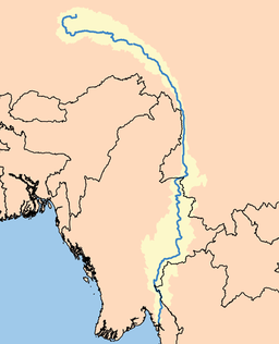
Salween drainage area
|
|
The Salween (Burmese: သံလွင်မြစ်; MLCTS: sam lwang mrac, IPA: [θàɴlwɪ̀ɴ mjɪʔ], is a river, about 2,815 kilometres (1,749 mi) long, that flows from the Tibetan Plateau into the Andaman Sea in Southeast Asia.
It drains a narrow and mountainous watershed of 324,000 square kilometres (125,000 sq mi) that extends into the countries of China, Burma and Thailand. Steep canyon walls line the swift, powerful and undammed Salween, one of the longest free-flowing rivers in the world. Its extensive drainage basin supports a biodiversity comparable with the Mekong and is home to about 7 million people. In 2003, key parts of the mid-region watershed of the river were included within the Three Parallel Rivers of Yunnan Protected Areas, a UNESCO World Heritage Site.
The people who live on the Salween are relatively isolated from the rest of the world. The river is only navigable up to 90 kilometres (56 mi) from the mouth, and only in the rainy season.
The Burma Road was constructed between 1937 and 1938 during the Second Sino-Japanese War and crossed the river at the Huitong bridge. The Huitong bridge was blown by the retreating Chinese army and the river became the frontline from 1942 to 1944. The Salween Campaign of World War II, was launched in order to liberate occupied China and open the Burma Road again and connect it to the Ledo Road.
...
Wikipedia


