Salt River (Wyoming)
| Salt River | |
|
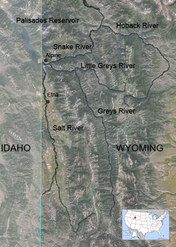
Map of Salt, Greys and Hoback River showing the Salt
|
|
| Country | United States |
|---|---|
| State | Wyoming |
| Source | |
| - location | Mount Wagner, Salt River Range, Wyoming |
| - coordinates | 42°35′38″N 110°48′08″W / 42.59389°N 110.80222°W |
| Mouth | Palisades Reservoir |
| - location | Alpine, Wyoming |
| - coordinates | 43°10′02″N 111°03′52″W / 43.16722°N 111.06444°WCoordinates: 43°10′02″N 111°03′52″W / 43.16722°N 111.06444°W |
| Length | 84 mi (135 km) |
| Basin | 890 sq mi (2,000 km2) |
The Salt River is an 84-mile-long (135 km) river draining a valley in Lincoln County in western Wyoming. It is named for several exposed beds of salt and briny salt springs of up 60% pure salt in Idaho that drains into the Salt River via Stump Creek. The Salt River valley was a popular destination for Indians and later pioneers seeking salt and game. The headwaters of the river are below 10,472-foot (3,192 m) Mount Wagner in the Salt River Range. The river flows west out of the mountains and then northward along the border of Wyoming and Idaho. It passes 6,600-foot (2,000 m) Smoot, Wyoming and then meanders through the mostly agricultural Star Valley, being joined by numerous creeks along the way, to its confluence with the Snake River near the town of Alpine (elevation 5,600 feet (1,700 m)).
The Salt River watershed drains about 890 square miles (2,300 km2) of the western part of the Salt River Range in Wyoming and the eastern part of the Caribou Range of Idaho. The Greys River, draining part of the eastern side of the Salt River Range, joins the Snake River just a few miles east of the mouth of the Salt River.
About halfway along its course, the Salt River passes through a section known as the "Narrows", where it cuts between two ridges that divide Star Valley into an upper and lower valleys. The river's mouth is now inundated by the reservoir of the Palisades Dam in Idaho during high water. Paralleling the Salt River is Wyoming Highway 89 leading north to Teton and Yellowstone National Park.
The river is an excellent source for fly fishing for brook, rainbow, cutthroat and brown trout. The state ranks the Salt River Class 2 (red) – Very good trout waters – fisheries of statewide importance.
...
Wikipedia

