Salmon Creek Dam
| Salmon Creek Dam, Alaska | |
|---|---|

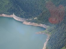
Aerial view of Salmon Creek Dam in Juneau, Alaska
|
|
|
Location of Salmon Creek Dam, Alaska in Alaska
|
|
| Official name | Salmon Creek Dam |
| Location | Juneau, Alaska, USA |
| Coordinates | 58°20′30″N 134°24′05″W / 58.34167°N 134.40139°WCoordinates: 58°20′30″N 134°24′05″W / 58.34167°N 134.40139°W |
| Construction began | July 24, 1913 |
| Opening date | August 13, 1914 |
| Owner(s) | Alaska Electric Light & Power (AEL&P) |
| Operator(s) | AEL&P |
| Dam and spillways | |
| Type of dam | Constant-angle concrete arch dam |
| Height | 175 ft (53 m) |
| Length | 645 ft (197 m) |
| Width (base) | 6.5 ft (2.0 m) at top and 47.5 ft (14.5 m) at base |
| Reservoir | |
| Creates | Salmon Creek Reservoir |
| Total capacity | 18,000 acre·ft (22,000,000 m3) |
| Catchment area | 7.5 sq mi (19 km2) |
| Surface area | 192 acres (78 ha) |
| Power station | |
| Operator(s) | AEL&P |
| Commission date | 1914 |
| Installed capacity | 6.7 MW |
| Annual generation | 29.5 GWh |
| Multi-purpose use | |
The Salmon Creek Dam is a concrete arch dam on the Salmon Creek, 3 miles (5 km) northwest of Juneau, Alaska. Built in 1914, it is the world's first constant-angle arch variable radius dam. Since it was built, over 100 such dams have been constructed all over the world.
The dam was built by the Alaska-Gastineau Mining Company to meet the electrical energy needs for mining operations. The dam continues to be fully functional for hydroelectric generation, as one of the drinking water sources to Juneau city and for aquaculture and fishing. When built, adoption of the constant arch design for the dam reduced costs by 20% because less concrete was needed to construct the dam. Of the two hydroelectric power stations built at the initial stage (one at the upper level and the other at the lower level) – the latter one is still in use after a new powerhouse was built adjoining the old one – it produces the inexpensive electricity in Alaska while meeting 10% of the energy needs of Juneau city. When built, the dam and its two power plants were considered engineering wonders. Both are operated and maintained by the Alaska Electric Light & Power (AEL&P).
The dam was built in a forested, scenic and narrow valley of the Salmon creek, which runs from Salmon Creek Reservoir and flows southwest for 3 miles (4.8 km) to the Gastineau Channel. The dam (marked as Juneau B-2 in USGS maps) is located at the terminus of the tram-way that was built specifically by the Alaska Gastineau Mining Co. The tram-way was built for hauling material for constructing the dam and its associated power stations. The power supply was for the mines located at a site 6 miles (9.7 km) to the south at Sheep Creek. However, a 3 miles (4.8 km) long road had been built by AEL&P to the upper powerhouse at the base of the Salmon Creek Dam, which has since been de-commissioned.
The creek runs for a length of 3 miles (4.8 km) within the watershed, which has a creek divide of 1.5 miles (2.4 km) and a ridge line of 2.2 miles (3.5 km). The stream bed has large gravel and bedrock substrata and its gradient decreases downstream of the dam. The average width of the stream is 30 feet (9.1 m) and depth of water is about 1.5 feet (0.46 m). The basin is surrounded by hills with steep slopes and with elevation above 980 feet (300 m) above sea level. The distance from the dam to Juneau city is 2.9 miles (4.7 km), to the Juneau harbor is 3.2 miles (5.1 km), and to the Juneau Harbor Seaplane Base is 3.4 miles (5.5 km).
...
Wikipedia

