Salisbury Township, Lehigh County, Pennsylvania
| Salisbury Township | |
| Township | |
|
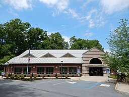
Salisbury Township Office.
|
|
| Country | United States |
|---|---|
| State | Pennsylvania |
| County | Lehigh |
| Elevation | 354 ft (107.9 m) |
| Coordinates | 40°34′46″N 75°30′09″W / 40.57944°N 75.50250°WCoordinates: 40°34′46″N 75°30′09″W / 40.57944°N 75.50250°W |
| Area | 11.1 sq mi (28.7 km2) |
| - land | 11.0 sq mi (28 km2) |
| - water | 0.1 sq mi (0 km2), 0.9% |
| Population | 13,505 (2010) |
| Density | 1,224.9/sq mi (472.9/km2) |
| Timezone | EST (UTC-5) |
| - summer (DST) | EDT (UTC-4) |
| Area code | 610 |
|
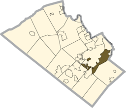
Location of Salisbury Township in Lehigh County
|
|
|
Location of Pennsylvania in the United States
|
|
| Website: http://www.salisburytownshippa.org | |
Salisbury Township is a township in Lehigh County, Pennsylvania, in the United States. The township borders Allentown (the third largest municipality in Pennsylvania), Bethlehem, and Emmaus, in the Lehigh Valley region.
The population of Salisbury Township was 13,505 at the 2010 census.
The township is home of the South Mall.
According to the United States Census Bureau, the township has a total area of 11.1 square miles (28.9 km2), of which, 11.0 square miles (28.5 km2) of it is land and 0.1 square miles (0.3 km2) of it (1.08%) is water. It is drained by the Lehigh River, which separates it from Bethlehem and the east side of Allentown, and its border with Upper Saucon is on Lehigh Mountain. Elevations range from approximately 300 feet on the river to at least 1,000 feet in Big Rock County Park.
Emmaus and Allentown share a border, separating Salisbury into two demographically-distinct non-contiguous portions. The township's villages of Farmington, Gauff Hill, and Summit Lawn (also in Upper Saucon Township) are in the eastern portion. The CDP of Dorneyville is in both the extreme northwestern part of the township and in South Whitehall Township.
As of the census of 2010, there were 13,505 people, 5,5595 households, and 3,832 families residing in the township. The population density was 1,224.9 people per square mile (472.9/km2). There were 5,595 housing units at an average density of 495.1 per square mile (191.0/km2). The racial makeup of the township was 91.39% White, 2.93% African American, 0.03% Native American, 1.60 Asian, 0.02% Pacific Islander, 2.40% from other races, and 1.63% from two or more races. Hispanic or Latino of any race were 2.14% of the population.
...
Wikipedia


