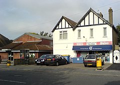
Salfords
| Salfords | |
|---|---|
 Community Centre, phone box and newsagent |
|
| Salfords shown within Surrey | |
| Population | Approx. 1900 (2001) |
| OS grid reference | TQ279463 |
| • London | 21 miles (34 km) |
| Civil parish | |
| District | |
| Shire county | |
| Region | |
| Country | England |
| Sovereign state | United Kingdom |
| Post town | Redhill |
| Postcode district | RH1 |
| Dialling code |
01293 01737 |
| Police | Surrey |
| Fire | Surrey |
| Ambulance | South East Coast |
| EU Parliament | South East England |
| UK Parliament | |
Salfords /ˈsælfʊdz/ SAL-fudz) is a village in the borough of Reigate and Banstead in Surrey, England. It lies approximately 3 miles (4.8 km) south of Redhill on the A23 London to Brighton road. The village is within the civil parish of Salfords and Sidlow which covers a population of 3,069, and has a parish council.
Salfords means "willow-tree ford" from Old English sealh/salh "willow" and ford "ford. The name was recorded Selefrid in 1193. This is similar to the derivation of Salford, Greater Manchester.
The village has its own 20th century church, Christ The King, primary school,cricket club, some shops, cafes, a social club, a tanning salon, a number of restaurants and a take away. Salfords Stream runs through the village and can cause flooding in the autumn and winter months. The southern boundary is marked by the Burstow stream. Both are minor River Mole tributaries, itself a tributary of the River Thames. The only old enough building to be a listed structure in the village are two adjoining houses on Brighton Road and The Mill House Hotel on the Salfords Stream.
...
Wikipedia

