Sal, Cape Verde (municipality)
| Sal | ||
|---|---|---|
| Municipality | ||

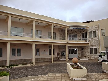
Municipal hall of Sal
|
||
|
||
 |
||
| Coordinates: 16°44′N 22°56′W / 16.73°N 22.93°WCoordinates: 16°44′N 22°56′W / 16.73°N 22.93°W | ||
| Country | Cape Verde | |
| Island | Sal | |
| Area | ||
| • Total | 219.8 km2 (84.9 sq mi) | |
| Population (2010) | ||
| • Total | 25,481 | |
| • Density | 120/km2 (300/sq mi) | |
Sal is a concelho (municipality) of Cape Verde. It covers the whole island of Sal. Its capital is the town Espargos. The municipality consists of one freguesia (civil parish), Nossa Senhora das Dores, which also covers the whole island. The freguesia is subdivided into the following settlements:
Sal’s main town, Espargos, is home to one of the nation’s international airports and has around 17,000 inhabitants. Sal's population grew around salt collection and later shifted to fishing, but is now based on tourism (amounting to 50% of the archipelago’s tourism) at the beach resort of Santa Maria.
Its airport, Amílcar Cabral International Airport, was used as a refuelling base by South African Airways on its Johannesburg to London routes. Later, flights to and from New York City and Atlanta also refuelled there, and the island was a crew-change station. SAA established the long runways needed by the fully fueled Boeing 707s on their take-offs in the high temperatures. On July 1, 2006, SAA operated its final flight to Sal due to the ending of its flights to Atlanta.
Saline marshes can be found in the Pedra de Lume crater and north of Santa Maria.
The major roads on the island are:
There are six inhabited centers:
Other inhabited settlements are:
It was created in 1935, when, due to a population increase, it was separated from the older Municipality of Boa Vista. The seat was originally at Santa Maria, as Espargos was founded, it became a secondary seat and Espargos became a municipal seat in the 1960s.
A large growing population has now is leading to the division of the municipality, it was first plan on April 7, 2014, no date of the separation has been set. It would form the municipalities of Espargos and Santa Maria, the municipal boundary would be marked north of Ilhéu Rabo de Junco, north of Murdeira and south of the airport, probably in the east-west line, also Nossa Senhora das Dores will exclude Espargos, one of the parish names could be São José, its nearby church.
...
Wikipedia

