Saint Lucia
|
Saint Lucia |
|||||
|---|---|---|---|---|---|
|
|||||
|
Motto: "The Land, The People, The Light"
|
|||||

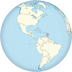
Location of Saint Lucia (circled in red)
in the Caribbean (light yellow) |
|||||
 |
|||||
| Capital and largest city |
Castries 14°1′N 60°59′W / 14.017°N 60.983°W |
||||
| Official languages | English | ||||
| Vernacular languages |
Saint Lucian Creole French | ||||
| Ethnic groups (2010) | |||||
| Demonym | Saint Lucian | ||||
| Government | Parliamentary democracy under constitutional monarchy | ||||
|
• Monarch
|
Elizabeth II | ||||
| Pearlette Louisy | |||||
| Allen Chastanet | |||||
| Legislature | Parliament | ||||
| Senate | |||||
| House of Assembly | |||||
| Independence | |||||
| 1 March 1967 | |||||
|
• from the United Kingdom
|
22 February 1979 | ||||
| Area | |||||
|
• Total
|
617 km2 (238 sq mi) (191st) | ||||
|
• Water (%)
|
1.6 | ||||
| Population | |||||
|
• 2015 UN estimate
|
184,999 | ||||
|
• 2010 census
|
165,595 | ||||
|
• Density
|
300/km2 (777.0/sq mi) | ||||
| GDP (PPP) | 2016 estimate | ||||
|
• Total
|
$2.083 billion | ||||
|
• Per capita
|
$11,970 | ||||
| GDP (nominal) | 2016 estimate | ||||
|
• Total
|
$1.439 billion | ||||
|
• Per capita
|
$8,268 | ||||
| HDI (2014) |
high · 89th |
||||
| Currency | East Caribbean dollar (XCD) | ||||
| Time zone | (UTC−4) | ||||
| Drives on the | left | ||||
| Calling code | +1 758 | ||||
| ISO 3166 code | LC | ||||
| Internet TLD | .lc | ||||
Coordinates: 13°53′N 60°58′W / 13.883°N 60.967°W
in the Caribbean (light yellow)
Saint Lucia (![]() i/seɪnt ˈluːʃə/; French: Sainte-Lucie) is a sovereign island country in the eastern Caribbean Sea on the boundary with the Atlantic Ocean. Part of the Lesser Antilles, it is located north/northeast of the island of Saint Vincent, northwest of Barbados and south of Martinique. It covers a land area of 617 km2 (238.23 sq mi) and reported a population of 165,595 in the 2010 census. Its capital is Castries.
i/seɪnt ˈluːʃə/; French: Sainte-Lucie) is a sovereign island country in the eastern Caribbean Sea on the boundary with the Atlantic Ocean. Part of the Lesser Antilles, it is located north/northeast of the island of Saint Vincent, northwest of Barbados and south of Martinique. It covers a land area of 617 km2 (238.23 sq mi) and reported a population of 165,595 in the 2010 census. Its capital is Castries.
...
Wikipedia


