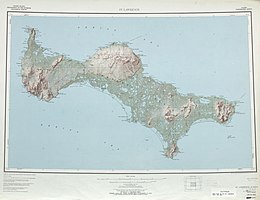
Saint Lawrence Island

Closeup map of St. Lawrence Island
|
|
|
Location in Alaska
|
|
| Geography | |
|---|---|
| Location | Bering Sea |
| Coordinates | 63°24′N 170°10′W / 63.400°N 170.167°WCoordinates: 63°24′N 170°10′W / 63.400°N 170.167°W |
| Area | 1,791.56 sq mi (4,640.1 km2) |
| Length | 90 mi (140 km) |
| Width | 22 mi (35 km) |
| Highest point | Atuk Mountain, 2,070 ft |
| Administration | |
|
United States
|
|
| State | Alaska |
| Largest settlement | Gambell (pop. 653) |
| Demographics | |
| Population | 1352 (2010) |
| Pop. density | 0.28 /km2 (0.73 /sq mi) |
St. Lawrence Island (Central Siberian Yupik: Sivuqaq) is located west of mainland Alaska in the Bering Sea, just south of the Bering Strait. The village of Gambell is located on the northwest cape, 36 miles (58 kilometers) from the Chukchi Peninsula in the Russian Far East. The island is part of Alaska, but closer to Siberia than to the Alaskan mainland. St. Lawrence Island is thought to be one of the last exposed portions of the land bridge that once joined Asia with North America during the period. It is the sixth largest island in the United States and the 113th largest island in the world. It is considered part of the Bering Sea Volcanic Province.
The United States Census Bureau defines St. Lawrence Island as Block Group 6, Census Tract 1 of Nome Census Area, Alaska. As of the 2000 census there were 1,292 people living on a land area of 1,791.56 sq mi (4,640.1 km2). The island is about 90 miles (140 km) long and 8–22 miles (13–36 km) wide. The island has no trees, and the only woody plants are Arctic willow, standing no more than a foot (30 cm) high.
The island's abundance of seabirds and marine mammals is due largely to the influence of the Anadyr Current, an ocean current which brings cold, nutrient-rich water from the deep waters of the Bering Sea shelf edge.
...
Wikipedia

